- Location: Mid-Wales
- Type: Stream
- Catchment area: 389 ha
- Annual rainfall: c. 2600 mm
- Sampling station altitude: 380 m
- Maximum altitude: 730 m
The Afon Gwy lies to the east of Plynlimon in central Wales and forms part of the headwater system of the River Wye. The catchment area is 389 ha and rises from 380 m at the sampling station to a maximum altitude of 730 m. Catchment soils are dominated by peats and stagnopodsols. The underlying geology is Lower Palaeozoic mudstones, shales and grits of the Gwestyn and Van formations, overlain in places by locally-derived glacial drift. The catchment consists of moorland grasses, notably Molinia and Nardus, with Eriophorum and the moss Racomitrium on areas of wetter land and Pteridium on the lower slopes. The majority of this grassland supports rough grazing for sheep and in summer, on the lower land, cattle. The local area is crossed with tracks used for rally testing, one of which passes through the southern edge of the catchment.
More than half of the western side of the catchment falls within a SSSI and the stream itself forms the headwater part of the River Wye/Afon Gwy SSSI and SAC.
The area receives annual rainfall of c. 2600 mm.
The altitude range is from 440 m to 700 m in the headwaters. The channel section utilised for biological sampling is 3-4 m wide and comprises a series of bedrock ledges, falls and boulder strewn riffles.
Next to the biological sampling stretch is situated a bulk precipitation collector for the UK Eutrophying and Acidifying atmospheric Pollutants (UKEAP) network, data from which are available here.
[collapsed title="Water chemistry"]
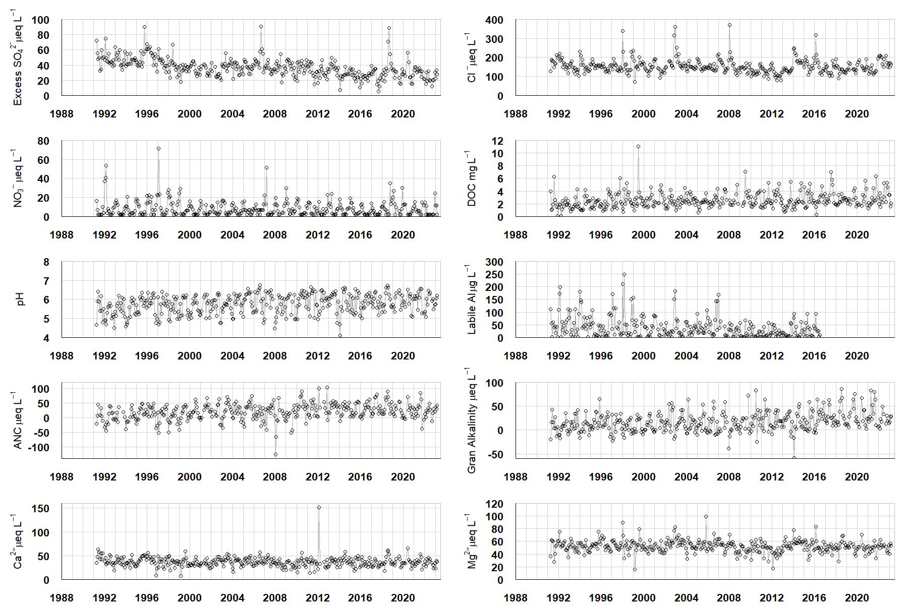
Excess SO42- = all sulphate not derived from marine salts; Cl- = chloride; NO3- = nitrate; DOC = dissolved organic carbon; Labile Al = inorganic monomeric (labile) aluminium; ANC = Acid Neutralising Capacity (determined by the difference (in equivalents) between total base cation concentration and total acid anion concentration); Gran Alkalinity = alkalinity determined by a Gran titration; Ca2+ = calcium; Mg2+ = magnesium.
[/collapse]
[collapsed title="Epilithic diatoms"]

Annual mean percentage abundance of the most common diatom taxa in replicate samples of the biofilm of stone surfaces. Taxa are arranged in the plot so that those that had their highest percentage abundances at the beginning of the monitoring record appear at the top of the figure, and those that have become most common at the end of the record appear at the bottom.
[/collapsed]
[collapsed title=Macroinvertebrates]
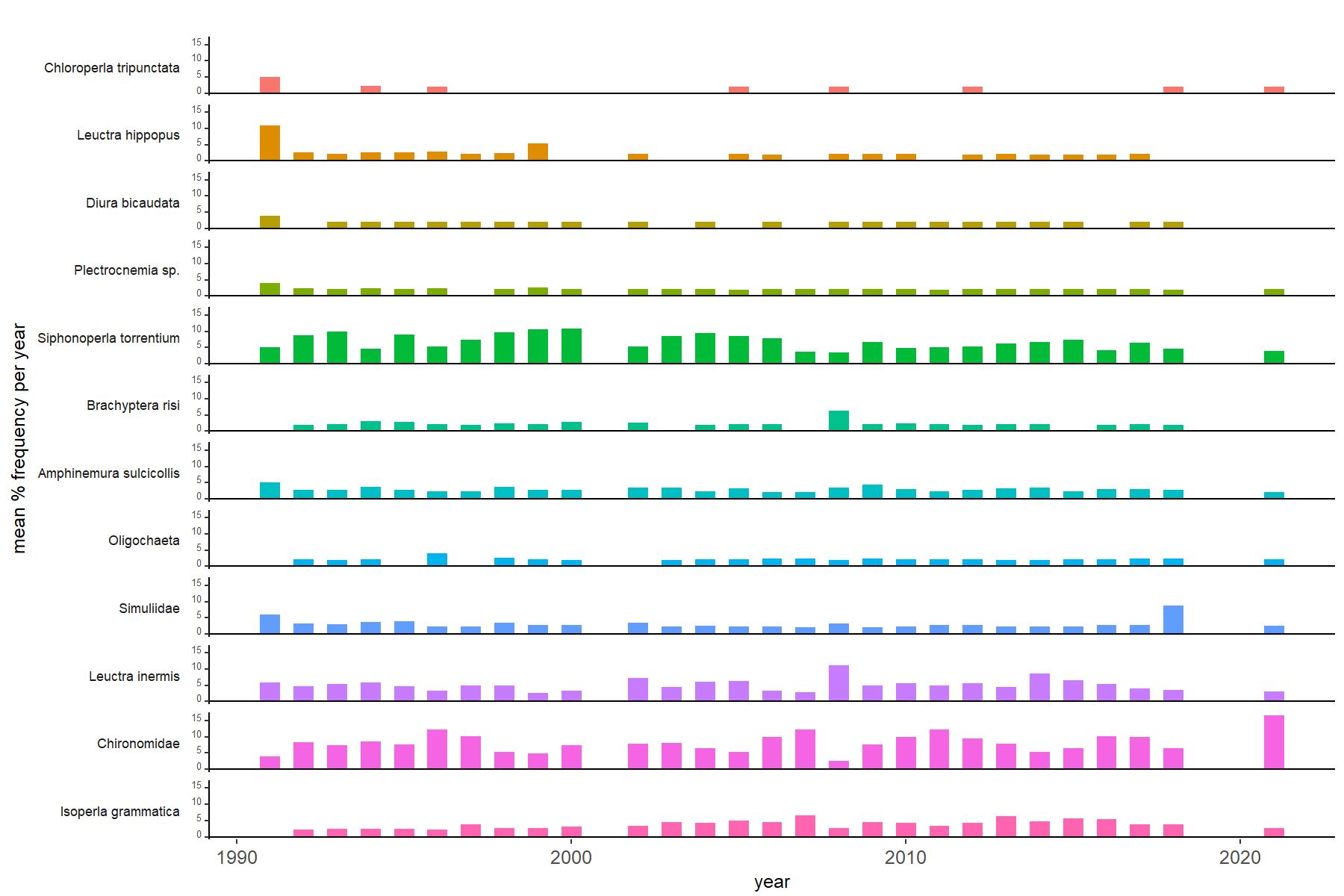
Abundance of the most common macroinvertebrate taxa as a percentage of all individuals collected in five bulked kick samples. Taxa are arranged in the plot so that those with their highest percentage abundances at the beginning of the monitoring record appear at the top of the figure, and those that have become most common at the end of the record appear at the bottom.
[/collapse]
These data are extracts from the latest annual report.
[collapsed title=Afon Gwy Bibliography]
[/collapse]