- Location: Mid-Wales
- Type: Stream
- Catchment area: 358 ha
- Annual rainfall: c. 2500 mm
- Sampling station altitude: 355 m
- Maximum altitude: 690 m
The Afon Hafren lies in the Cambrian Mountains of mid-Wales and from its confluence with the Afon Hore forms the headwaters of the River Severn. The catchment area is 358 ha and rises from 355 m at the sampling station to 690 m at Blaenhafren. Stagnoodsols cover approximately 40% of the catchment and organic peaty soils comprise the remaining area. The underlying geology consists of Ordovician grits and Silurian mudstones and shales.
Fifty percent of the catchment is planted with conifers, primarily Sitka and Norway spruce, and forms part of the larger Hafren Forest; planting took place primarily between 1948-1950 and 1963-1964. At the start of monitoring about 5% of the catchment consisted of recently felled forest. Since that time there has been steady harvesting and replanting of large areas continuing right up to the present day though this appears to have had little impact on stream water chemistry. Moorland grasses and Calluna occupy the remainder of the catchment (all of which is a SSSI) and are utilised for rough grazing. Prior to afforestation the catchment was exploited as upland sheepwalk.
Rainfall is c. 2500 mm annually.
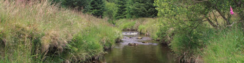
The altitude range is 335 m from the sampling station to the headwaters. The channel section utilised for biological sampling lies in a forest clearing and is circa 3.5 m wide comprising shallow rapids and a deep pool. The stream bed substrate consists largely of boulders, cobbles and pebbles.
The stream is a site in the UNECE International Cooperative Programme Integrated Monitoring Project.
[collapsed title="Water chemistry"]
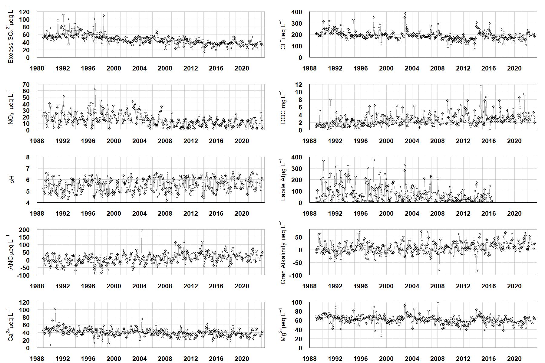
Excess SO42- = all sulphate not derived from marine salts; Cl- = chloride; NO3- = nitrate; DOC = dissolved organic carbon; Labile Al = inorganic monomeric (labile) aluminium; ANC = Acid Neutralising Capacity (determined by the difference (in equivalents) between total base cation concentration and total acid anion concentration); Gran Alkalinity = alkalinity determined by a Gran titration; Ca2+ = calcium; Mg2+ = magnesium.
[/collapse]
[collapsed title="Epilithic diatoms"]

Annual mean percentage abundance of the most common diatom taxa in replicate samples of the biofilm of stone surfaces. Taxa are arranged in the plot so that those that had their highest percentage abundances at the beginning of the monitoring record appear at the top of the figure, and those that have become most common at the end of the record appear at the bottom.
[/collapsed]
[collapsed title=Macroinvertebrates]
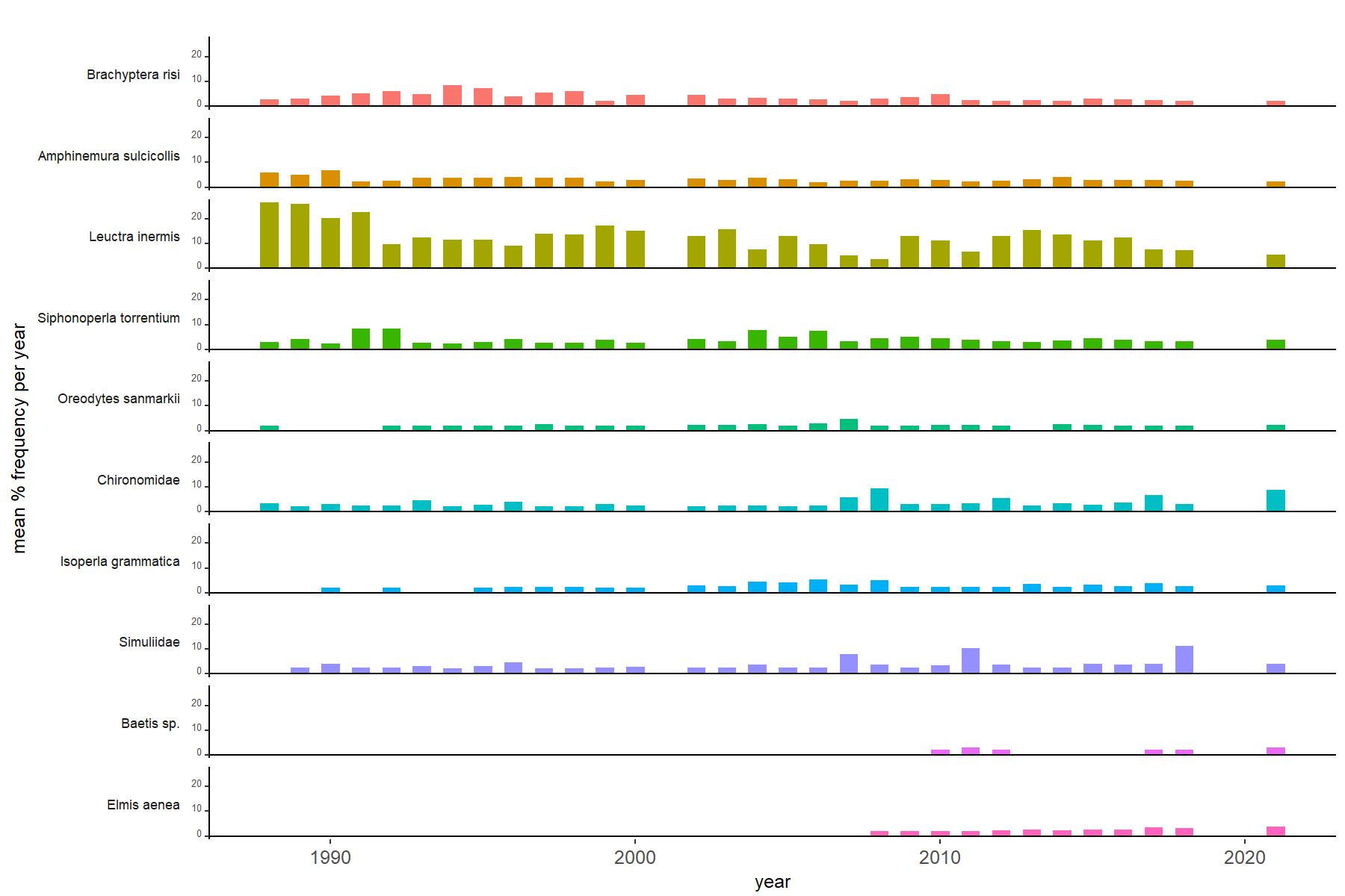
Abundance of the most common macroinvertebrate taxa as a percentage of all individuals collected in five bulked kick samples. Taxa are arranged in the plot so that those with their highest percentage abundances at the beginning of the monitoring record appear at the top of the figure, and those that have become most common at the end of the record appear at the bottom.
[/collapse]
[collapsed title=Afon Hafren Bibliography]
[/collapse]