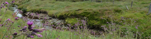
- Location: Sperrin Mountains of central Northern Ireland
- Type: Stream
- Catchment area: 1264 ha
- Annual rainfall: c. 1500 mm
- Sampling location altitude: 230 m
- Maximum altitude: 562 m
The Coneyglen Burn lies in the Sperrin Mountains of central Northern Ireland. The catchment area is 1264 ha and rises from 230 m at the sampling station to a maximum of 562 m at Carnanelly. The underlying geology is schists of the Mullaghcarn series, which occur in places as rocky outcrops. Catchment soils are dominated by blanket peats and peaty podsols. Adjacent to the stream the thin peat is interspersed with alluvium, sands and gravels.
Originally some 4% of the catchment (the lower section) was planted with conifers but this has increased slightly since 2000 as the forested area was enlarged. Previously improved grazing land in the middle section of the catchment, adjacent to a small farm, is no longer actively managed, except by grazing, and is reverting to moorland, with a predominance of Juncus species. Old field systems and drainage patterns suggest a higher intensity of land-use in the past. Elsewhere, the vegetation is characterised by moorland species, notably Calluna. Contemporary land-use and management is confined to low-intensity sheep grazing and infrequent heather burning.
The catchment lies within the Sperrin Area of Outstanding Natural Beauty.
The annual rainfall is c.1500 mm.
The altitude range is from 230 m at the sampling station to 460 m at the headwaters. The channel section utilised for biological sampling is straight and about 4 m wide and is characterised by shallow rapids with a stream bed comprising largely bedrock and boulders.
[collapsed title="Water chemistry"]
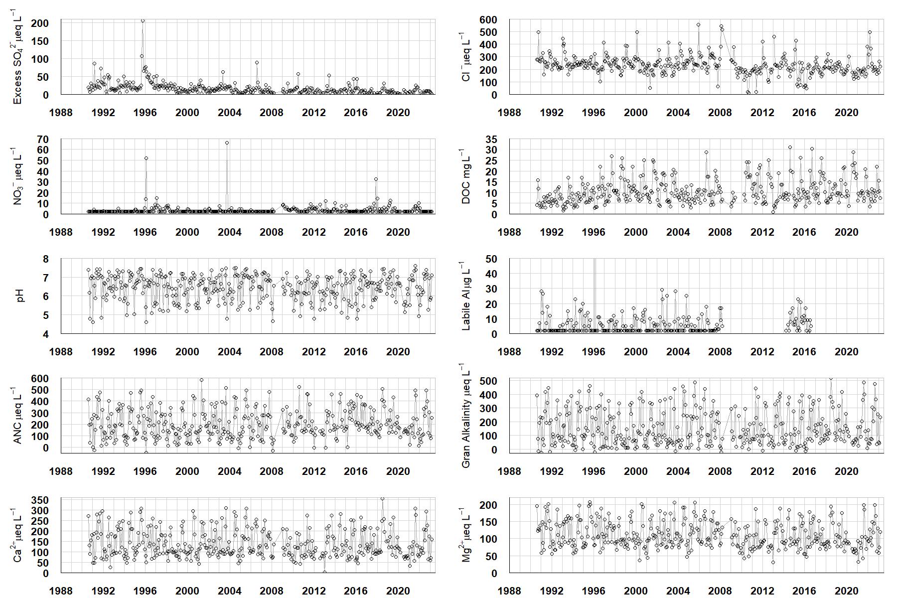
Excess SO42- = all sulphate not derived from marine salts; Cl- = chloride; NO3- = nitrate; DOC = dissolved organic carbon; Labile Al = inorganic monomeric (labile) aluminium; ANC = Acid Neutralising Capacity (determined by the difference (in equivalents) between total base cation concentration and total acid anion concentration); Gran Alkalinity = alkalinity determined by a Gran titration; Ca2+ = calcium; Mg2+ = magnesium.
[/collapse]
[collapsed title="Epilithic diatoms"]

Annual mean percentage abundance of the most common diatom taxa in replicate samples of the biofilm of stone surfaces. Taxa are arranged in the plot so that those that had their highest percentage abundances at the beginning of the monitoring record appear at the top of the figure, and those that have become most common at the end of the record appear at the bottom.
[/collapsed]
[collapsed title=Macroinvertebrates]
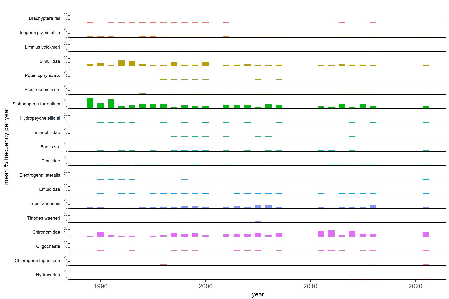
Abundance of the most common macroinvertebrate taxa as a percentage of all individuals collected in five bulked kick samples. Taxa are arranged in the plot so that those with their highest percentage abundances at the beginning of the monitoring record appear at the top of the figure, and those that have become most common at the end of the record appear at the bottom.
[/collapse]
[collapsed title=Coneyglen Burn Bibliography]
[/collapse]