- Location: Dartmoor National Park, south-west England
- Type: Stream
- Catchment area: 446 ha
- Annual rainfall: c. 1800 mm
- Sampling location altitude: 225 m
- Maximum altitude: 456 m
Narrator Brook lies in the Dartmoor National Park, south-west England. The study catchment covers 446 ha and drains into the Burrator Reservoir. The altitude at the reservoir inflow is 225 m and a maximum altitude is reached at Cairn Eylesbarrow (456 m). The underlying geology is composed of granite and soils consist of brown podsols, stagnopodsols and stagnohumic gleys. Molinia dominated blanket bog comprises about two thirds of the catchment, with acid grassland invaded by Pteridium, conifers, deciduous woodland and valley bog constituting the remainder. The catchment is utilised for low-intensity grazing by sheep, cattle and ponies and a small area at the western end is common land, but other land-management is minimal. The conifers, which are not planted to the stream edge, were planted in 1931-1933 and thinned (and replanted in places) between 1980 and 1988. They now fall within a Woodland Grant Scheme.
The catchment lies inside the Dartmoor National Park, a designated Environmentally Sensitive Area and a "Severely Disadvantaged" Less Favoured Area.
Annual rainfall is c. 1800 mm.
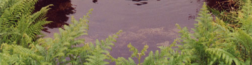
The stream section utilised for biological monitoring is located on an open floodplain section of the catchment upstream of the conifers and includes a cobble-strewn shaded upstream reach, a narrow (1-2 m wide) fast flowing section and a deep pool where gravel and sand substrates predominate.
The water chemistry sampling location was moved upstream in 1991 due to a period of timber felling in the lower catchment. Some fencing was erected alongside the macrophyte monitoring stretch in the late 1990s and this has allowed the growth of scrub in places alongside the stream bank.
[collapsed title="Water chemistry"]
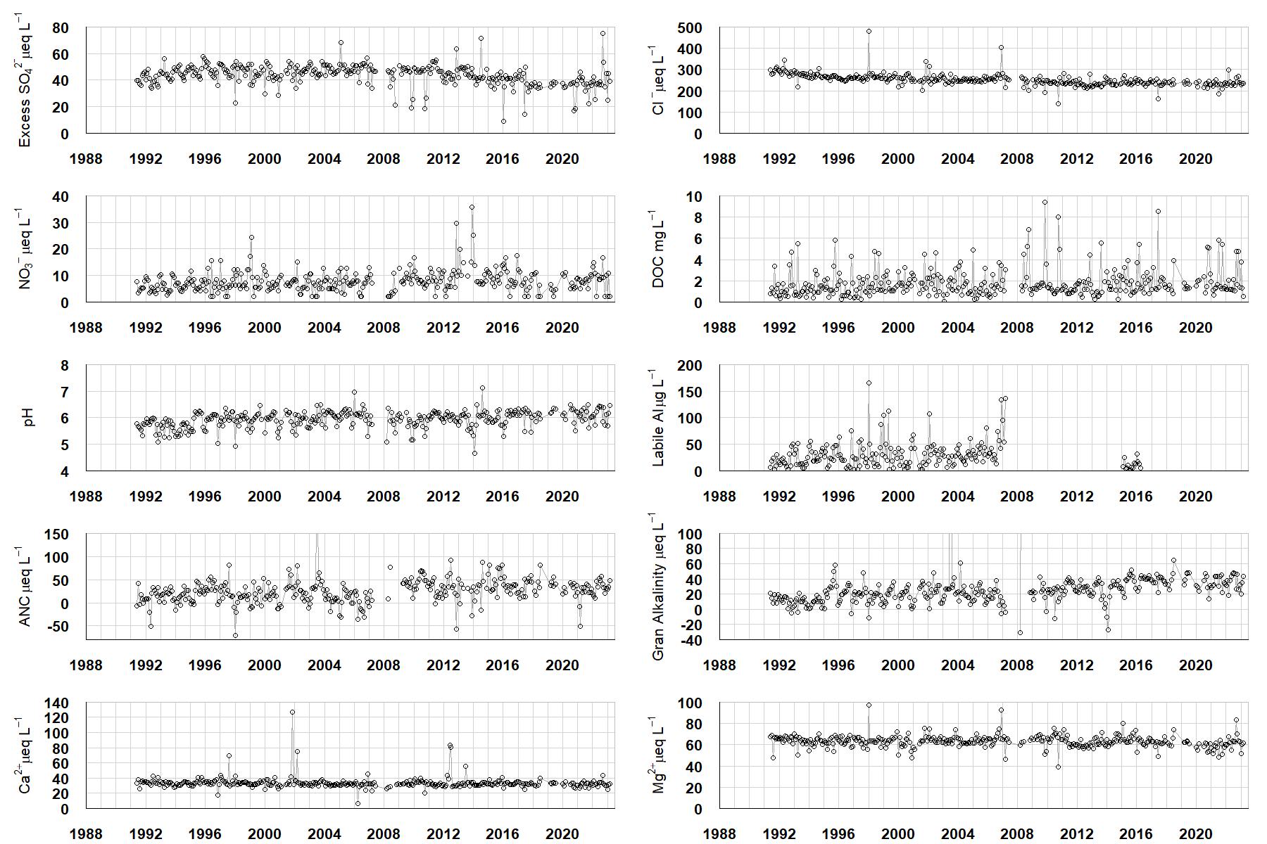
Excess SO42- = all sulphate not derived from marine salts; Cl- = chloride; NO3- = nitrate; DOC = dissolved organic carbon; Labile Al = inorganic monomeric (labile) aluminium; ANC = Acid Neutralising Capacity (determined by the difference (in equivalents) between total base cation concentration and total acid anion concentration); Gran Alkalinity = alkalinity determined by a Gran titration; Ca2+ = calcium; Mg2+ = magnesium.
[/collapse]
[collapsed title="Epilithic diatoms"]

Annual mean percentage abundance of the most common diatom taxa in replicate samples of the biofilm of stone surfaces. Taxa are arranged in the plot so that those that had their highest percentage abundances at the beginning of the monitoring record appear at the top of the figure, and those that have become most common at the end of the record appear at the bottom.
[/collapsed]
[collapsed title=Macroinvertebrates]
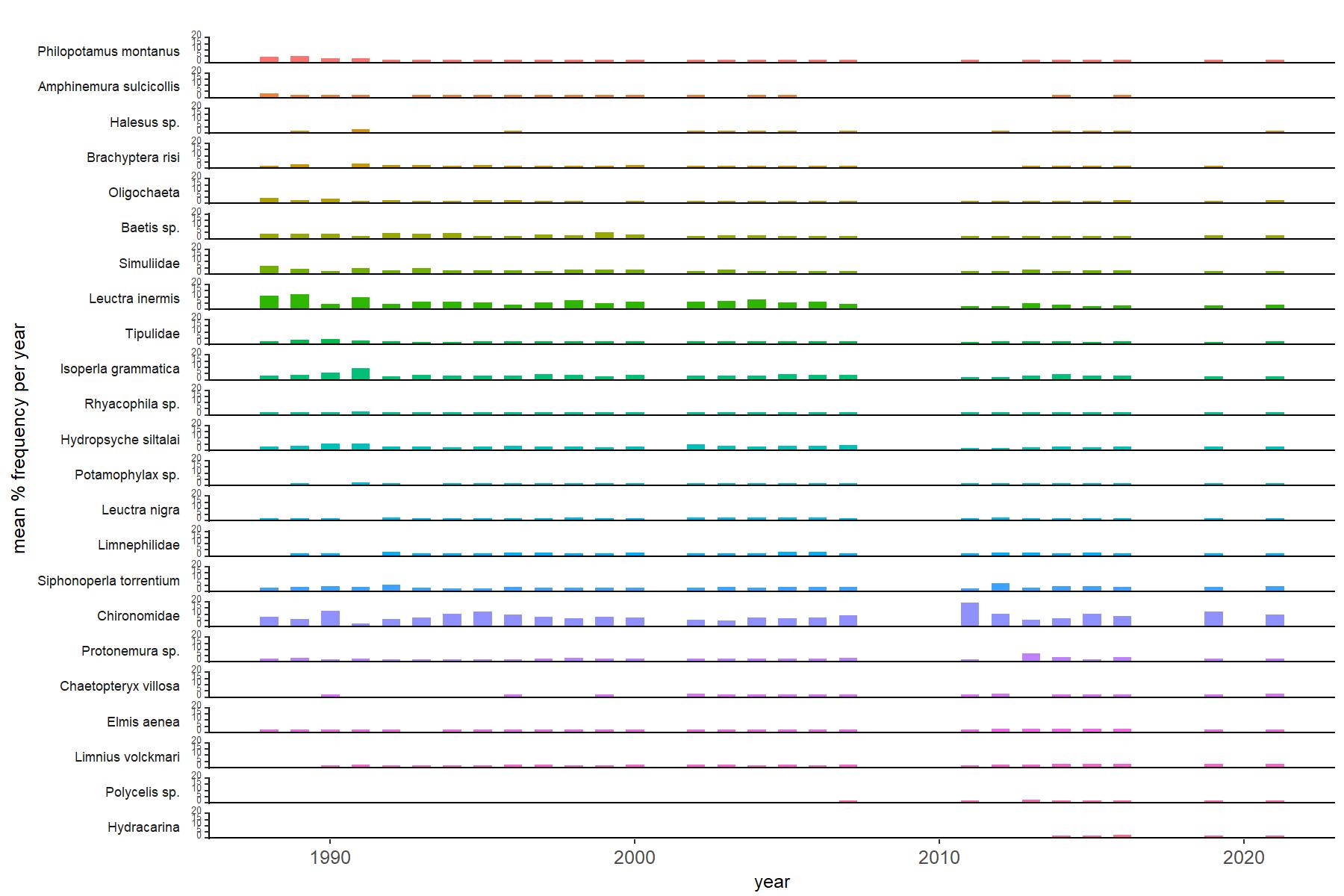
Abundance of the most common macroinvertebrate taxa as a percentage of all individuals collected in five bulked kick samples. Taxa are arranged in the plot so that those with their highest percentage abundances at the beginning of the monitoring record appear at the top of the figure, and those that have become most common at the end of the record appear at the bottom.
[/collapse]
[collapsed title=Narrator Brook Bibliography]
[/collapse]