- Location: Ashdown Forest, south east England
- Type: Stream
- Catchment area: 301 ha
- Annual rainfall: c. 900 mm
- Sampling location altitude: 94 m
- Maximum altitude: 223 m
The Old Lodge catchment lies in south east England within Ashdown Forest and is the most easterly site of the Monitoring Network. The catchment area is 301 ha with an altitude range between 94 m at the stream confluence with Mill Brook and 223 m at Camp Hill. The underlying geology is comprised of the Ashdown Formation and catchment soils are gley podsols.
Approximately 15% of the catchment is deciduous woodland, principally around the sampling station. Conifers occupy less than 5% of the catchment with the remainder classified as heathland vegetation dominated by Calluna and Erica, with abundant stands of Pteridium. The Conservators of Ashdown Forest and the Sussex Wildlife Trust, who own the bulk of the catchment, practice winter tree clearance for heathland retention and to this end a low level cattle and sheep grazing regime was instigated in 1998. Much of the catchment is common land. There has been little land-use disturbance for at least the past 200 years, although severe wind-throw affected many trees after the storms of October 1987.
Annual rainfall is c. 900 mm.
The catchment lies within the High Weald Area of Outstanding National Beauty. With the exception of the north western area around Old Lodge, most of the catchment is covered by a large number of designations; it is a Birds Directive Special Protection Area and an RSPB Important Bird Area; it is under a Higher Level Countryside Stewardship agreement; it is in the Ashdown Forest SSSI and Special Area of Conservation and it is also lowland heathland BAP priority habitat.
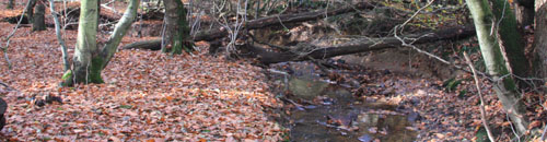
The stream section utilised for biological monitoring is c.3 m wide and heavily shaded in summer by the deciduous tree canopy (notably Fagus) and several trees have fallen across the watercourse. The stream bed comprises mainly boulders, cobbles and gravel and the sampling reach contains very shallow water during dry-weather flow with numerous riffle sections.
UK UWMN data from Old Lodge are contributed to the UK Environmental Change Network, the European Long-Term Ecosystem Research Network (LTER-Europe) and the International Long Term Ecological Research (ILTER) programme.
[collapsed title="Water chemistry"]
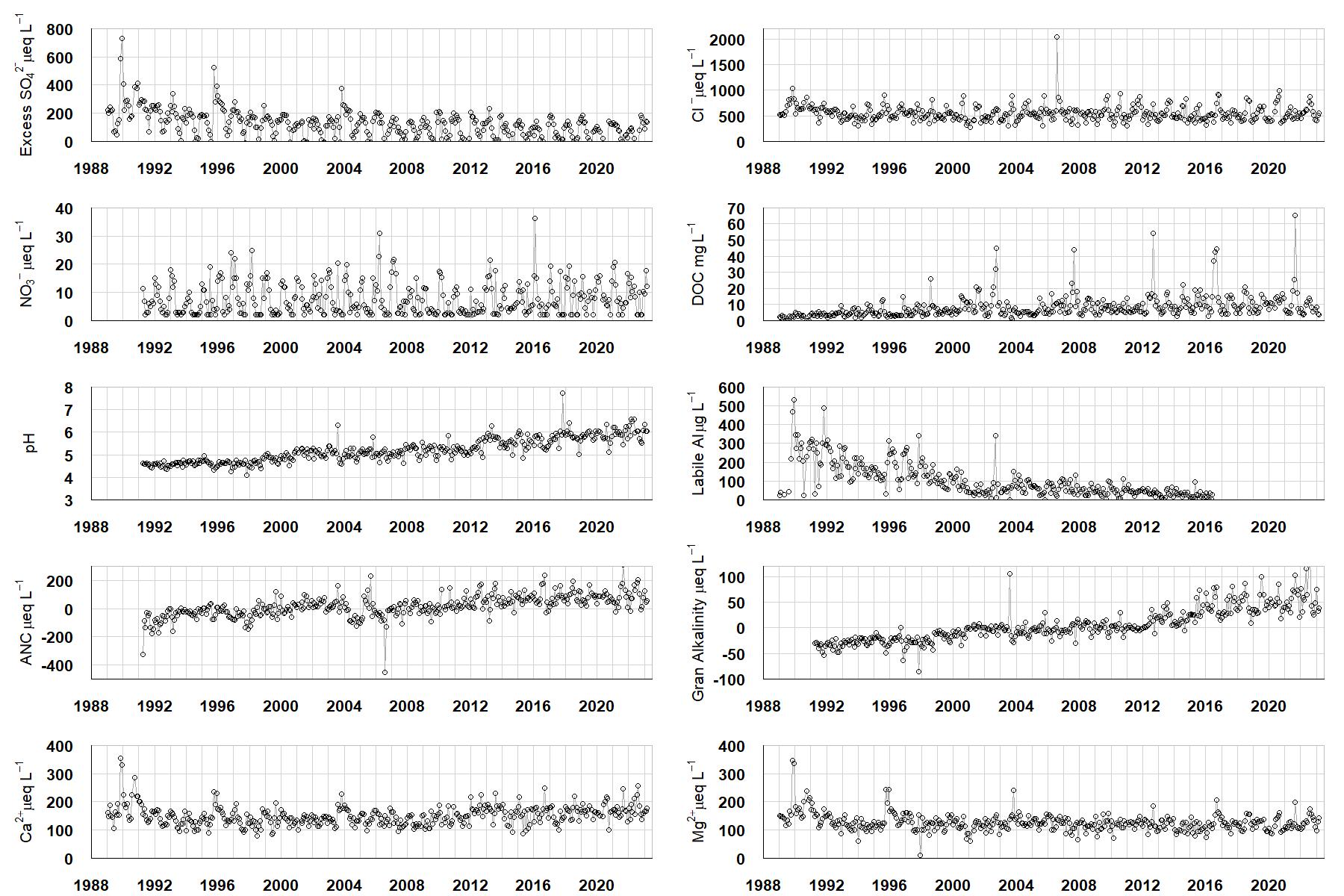
Excess SO42- = all sulphate not derived from marine salts; Cl- = chloride; NO3- = nitrate; DOC = dissolved organic carbon; Labile Al = inorganic monomeric (labile) aluminium; ANC = Acid Neutralising Capacity (determined by the difference (in equivalents) between total base cation concentration and total acid anion concentration); Gran Alkalinity = alkalinity determined by a Gran titration; Ca2+ = calcium; Mg2+ = magnesium.
[/collapse]
[collapsed title="Epilithic diatoms"]

Annual mean percentage abundance of the most common diatom taxa in replicate samples of the biofilm of stone surfaces. Taxa are arranged in the plot so that those that had their highest percentage abundances at the beginning of the monitoring record appear at the top of the figure, and those that have become most common at the end of the record appear at the bottom.
[/collapsed]
[collapsed title=Macroinvertebrates]
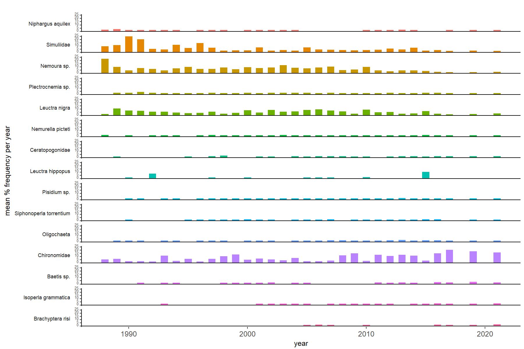
Abundance of the most common macroinvertebrate taxa as a percentage of all individuals collected in five bulked kick samples. Taxa are arranged in the plot so that those with their highest percentage abundances at the beginning of the monitoring record appear at the top of the figure, and those that have become most common at the end of the record appear at the bottom.
[/collapse]
[collapsed title=Old Lodge Bibliography]
[/collapse]