- Location: Pennine hills east of Manchester, northern England
- Type: River
- Catchment area: 1295 ha
- Annual rainfall: c. 1600 mm
- Sampling location altitude: 280 m
- Maximum altitude: 633 m
Situated in the Pennines east of Manchester, the upper catchment of the River Etherow drains an area of 1295 ha and flows into the Woodhead Reservoir, the first of a series of downstream reservoirs designed by John Frederick Bateman to supply water to the city. The highest point in the catchment, Bleaklow Head, lies at 633 m. The underlying geology is millstone grit and the soils are peats, stagnohumic gleys and stagnopodsols.
The moorland vegetation includes both improved and rough grazing land; Calluna and Vaccinium comprise the dominant vegetation with grasses (notably Agrostis and Molinia) and a scatter of deciduous trees (Betula and Quercus) accounting for the remaining areas. The lower land is predominantly utilised for sheep grazing whilst the upper area is grouse moor where heather burning is occasionally practised. The main A628 trunk road passes through the catchment and close to the sampling area and it appears that on occasion road salt applications may affect stream water chemistry.
Annual rainfall is c. 1600 mm.
The catchment falls within a variety of designated areas: the Dark Peak SSSI, the South Pennine Moors Special Area of Conservation, the Peak District Moors (South Pennine Moors Phase 1) Special Protection Area, an RSPB Important Bird Area, an Environmentally Sensitive Area and the Peak District National Park. The site is also surrounded on three sides by a Nitrate Vulnerable Zone.
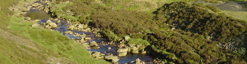
The altitude range is from 280 m at the sampling station to 620 m at the headwaters. The stream section utilised for biological sampling is c. 10 m wide and comprises a sequence of rapids and pools. The substrate is characterised by shallow bedrock ledges, large boulders and cobbles.
A bulk deposition collector is co-located within the catchment as part of the UK Eutrophying and Acidifying atmospheric Pollutants (UKEAP) network, data from which are available here.
[collapsed title="Water chemistry"]
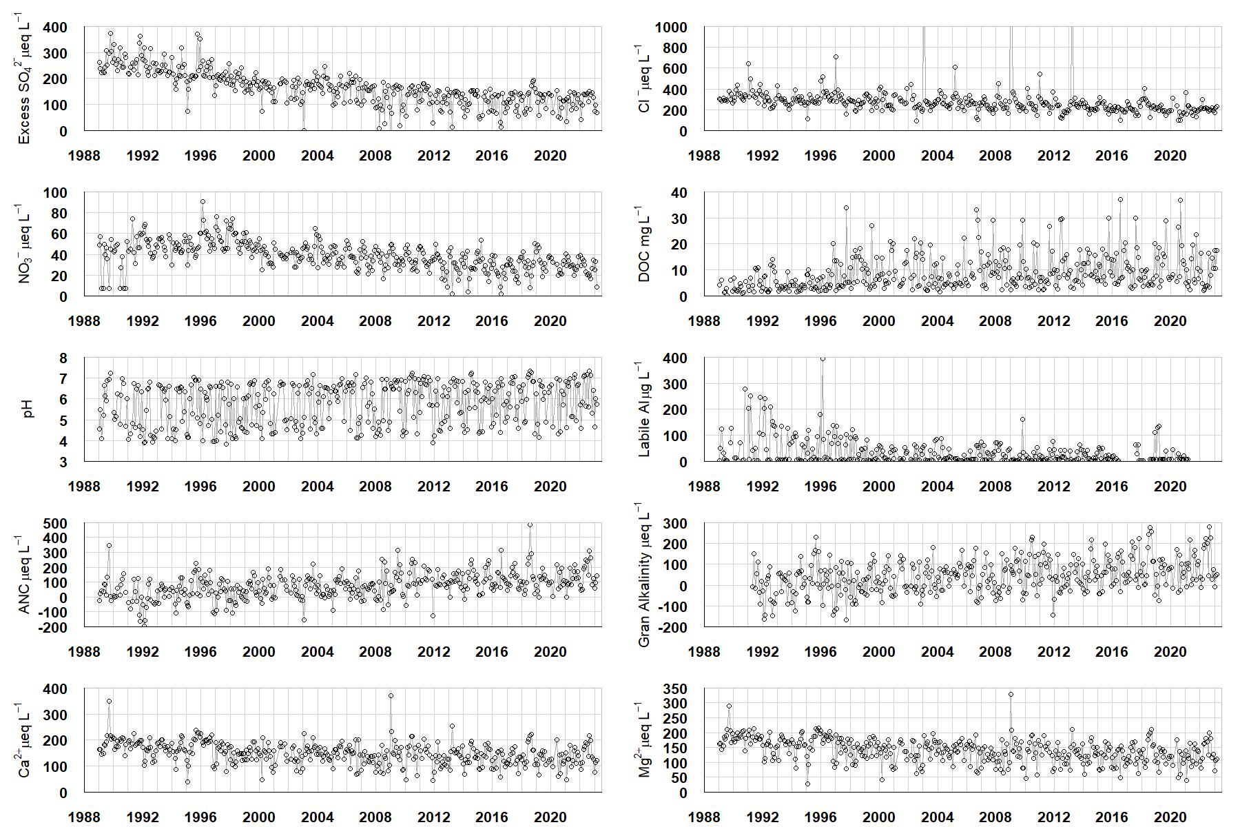
Excess SO42- = all sulphate not derived from marine salts; Cl- = chloride; NO3- = nitrate; DOC = dissolved organic carbon; Labile Al = inorganic monomeric (labile) aluminium; ANC = Acid Neutralising Capacity (determined by the difference (in equivalents) between total base cation concentration and total acid anion concentration); Gran Alkalinity = alkalinity determined by a Gran titration; Ca2+ = calcium; Mg2+ = magnesium.
[/collapse]
[collapsed title="Epilithic diatoms"]

Annual mean percentage abundance of the most common diatom taxa in replicate samples of the biofilm of stone surfaces. Taxa are arranged in the plot so that those that had their highest percentage abundances at the beginning of the monitoring record appear at the top of the figure, and those that have become most common at the end of the record appear at the bottom.
[/collapsed]
[collapsed title=Macroinvertebrates]
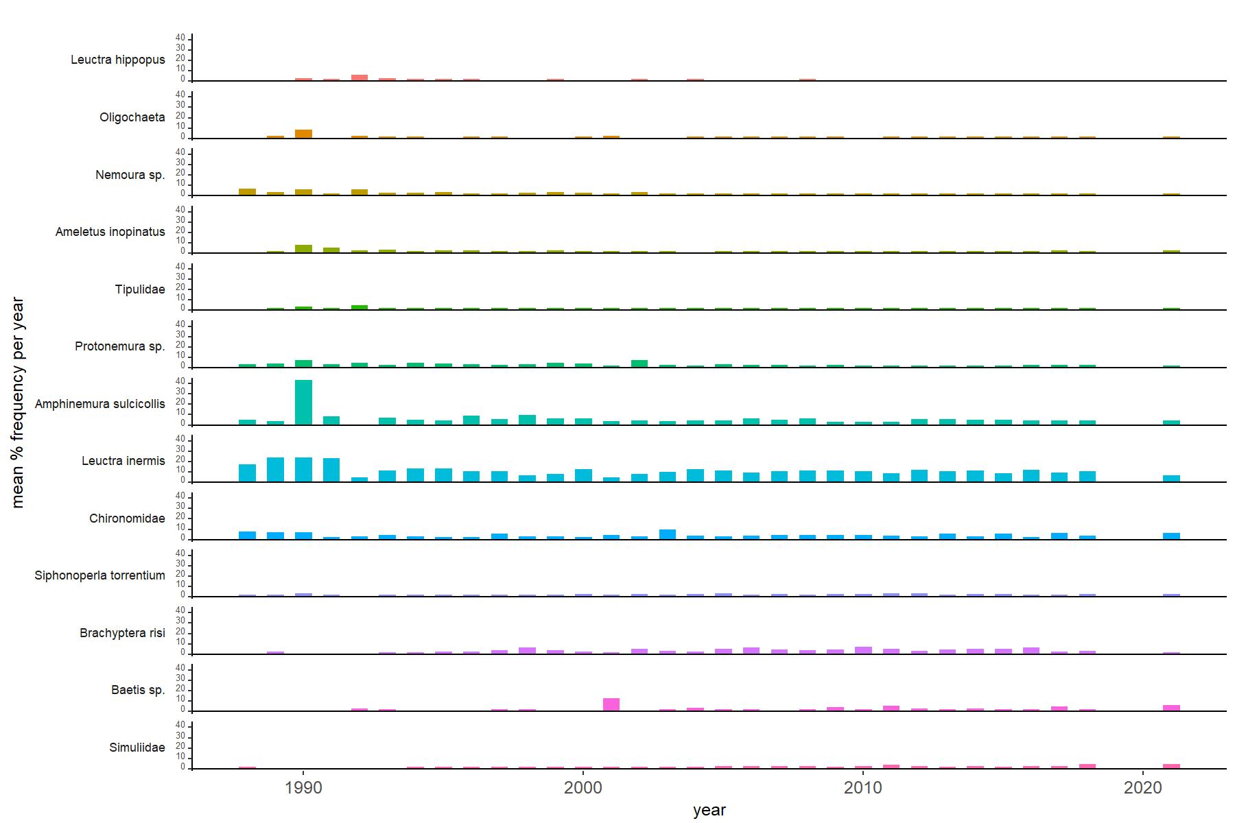
Abundance of the most common macroinvertebrate taxa as a percentage of all individuals collected in five bulked kick samples. Taxa are arranged in the plot so that those with their highest percentage abundances at the beginning of the monitoring record appear at the top of the figure, and those that have become most common at the end of the record appear at the bottom.
[/collapse]
[collapsed title=River Etherow Bibliography]
[/collapse]