- Location: Lake District, north-west England
- Type: Lake
- Catchment area: -
- Annual rainfall: c. 3500 mm
- Lake area: 4.3 ha
- Lake altitude: 598 m
The catchment of Scoat Tarn in the English Lake District comprises a small corrie with steeply sloping walls and three summits in excess of 825 m. The eastern slopes are mainly rock and boulders while those to the north and south are less steep and covered with rough grass and sphagnum as well as boulders.
The lake and its catchment receive an annual rainfall of c. 3500 mm.
The bedrock is Ordovician tuff (undifferentiated) of the Borrowdale Volcanic series. The local soils are classified as shallow, peaty rankers although a deeper soil profile exists in a few localised areas. The area is treeless moorland characterised by acid grassland species including Nardus stricta, Deschampsia flexuosa, Festuca ovina and Sphagnum spp. For the majority of monitoring land-use was confined to recreation and low intensity sheep grazing. Since 2008 there has also been a small amount of summer cattle grazing.
Owned by the National Trust, both the lake and catchment lie within an Environmentally Sensitive Area, the Lake District National Park and a "Severely Disadvantaged" Less Favoured Area. The northern half of the catchment is common land and the southern half falls under a DEFRA organic farming scheme agreement.
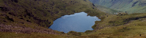
Scoat Tarn is a typical mountain corrie lake, being small and deep with an area of 4.3 ha and a maximum depth of 20 m. The lake lies in a west facing valley at an altitude of 598 m. Two small streams and several small trickles, some of which are covered by scree, drain from the steep catchment. The outflow from the western corner flows into Wastwater via the Nether Beck. The deepest part of the lake lies towards the steeper, south eastern shore and the mean depth of 10 m reflects the origin of the basin as the head of a glaciated valley. The littoral area is composed of gravels, bedrock and boulder scree, while there is an accumulation of over 2 m of post-glacial sediment towards the centre of the lake.
The tarn is part of the UNECE International Cooperative Programme on Assessment and Monitoring of Acidification of Rivers and Lakes and the catchment also hosts a collector for the UK Eutrophying and Acidifying atmospheric Pollutants (UKEAP) network, data from which are available here. UK UWMN data from Scoat Tarn are contributed to the UK Environmental Change Network, the European Long-Term Ecosystem Research Network (LTER Europe) and the International Long Term Ecological Research (ILTER) programme.
The lake has been designated as a site in the Environment Agency's Water Framework Directive Lake Surveillance Network. The UK UWMN contributes the biological and chemical data required for this statutory monitoring.
[collapsed title="Water chemistry"]
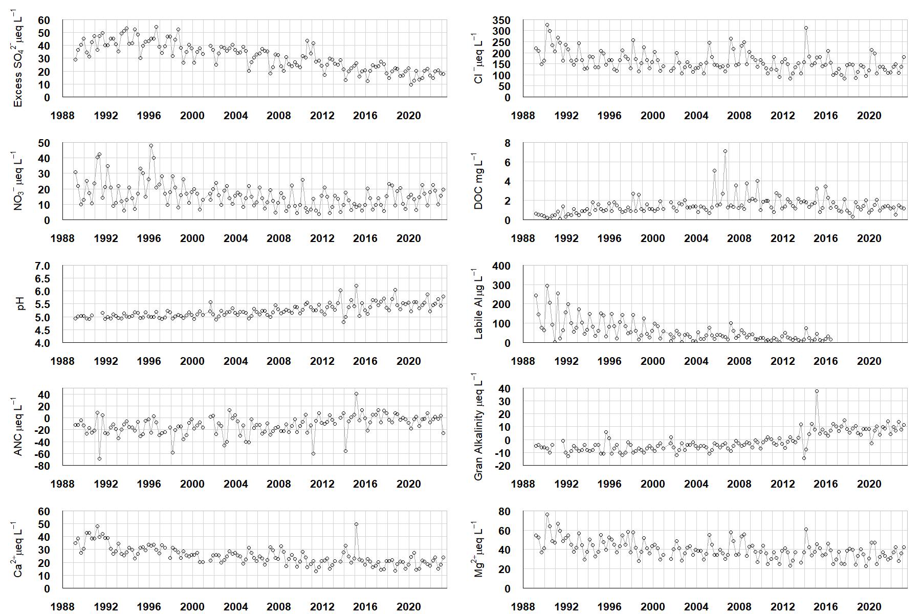
Excess SO42- = all sulphate not derived from marine salts; Cl- = chloride; NO3- = nitrate; DOC = dissolved organic carbon; Labile Al = inorganic monomeric (labile) aluminium; ANC = Acid Neutralising Capacity (determined by the difference (in equivalents) between total base cation concentration and total acid anion concentration); Gran Alkalinity = alkalinity determined by a Gran titration; Ca2+ = calcium; Mg2+ = magnesium.
[/collapse]
[collapsed title="Epilithic diatoms"]

Annual mean percentage abundance of the most common diatom taxa in replicate samples of the biofilm of stone surfaces. Taxa are arranged in the plot so that those that had their highest percentage abundances at the beginning of the monitoring record appear at the top of the figure, and those that have become most common at the end of the record appear at the bottom.
[/collapsed]
[collapsed title=Macroinvertebrates]
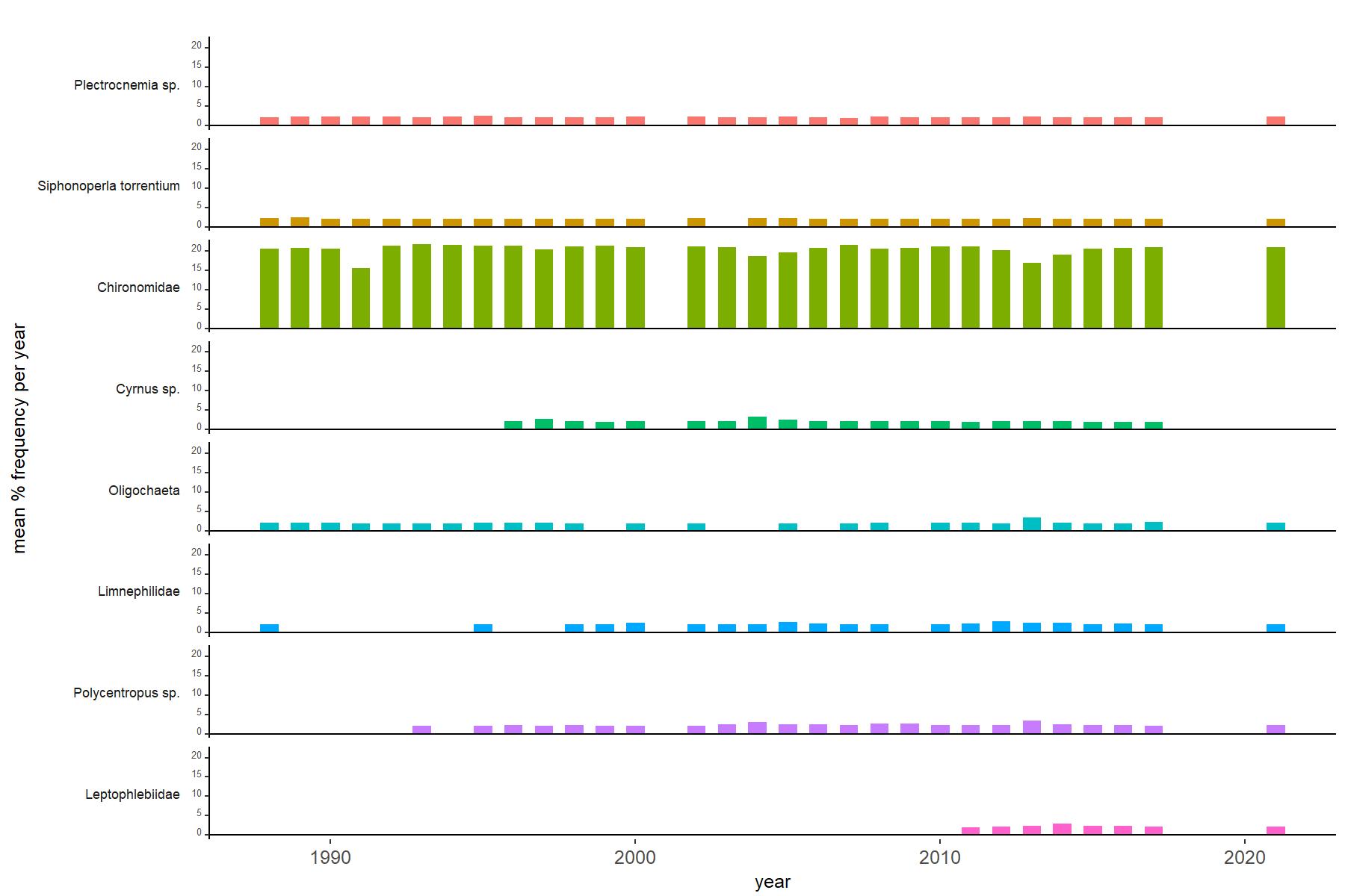
Abundance of the most common macroinvertebrate taxa as a percentage of all individuals collected in five bulked kick samples. Taxa are arranged in the plot so that those with their highest percentage abundances at the beginning of the monitoring record appear at the top of the figure, and those that have become most common at the end of the record appear at the bottom.
[/collapse]
[collapsed title=Scoat Tarn Bibliography]
[/collapse]