- Location: Cairngorm mountains, Scotland
- Type: Stream
- Catchment area: 979 ha
- Annual rainfall: c. 1100 mm
- Sampling station altitude: 325 m
- Maximum altitude: 1111 m
The Allt a'Mharcaidh catchment lies on the western flank of the Cairngorm Mountains. The catchment area is 979 ha and drains to the River Feshie, a tributary of the River Spey. The catchment rises from 325 m at the sampling station to 1111 m at Sgoran Dubh Mor. Subalpine soils cover 60% and alpine soils and rankers 40% of the catchment area. The underlying geology is intrusive biotite-granite of Lower Old Red Sandstone age.
Vegetation in the catchment is characterised by a heather/fescue grass mixture (c. 95%) with native Pinus sylvestris pinewoods (c. 5%) interspersed along the lowest reaches. The catchment comprises part of the Cairngorm National Nature Reserve and is also in a SSSI, a Special Area of Conservation and a Special Protection Area. The catchment lies wholly within the Cairngorm National Park. Land-use is confined to deer grazing.
Annual rainfall is c. 1100 mm.
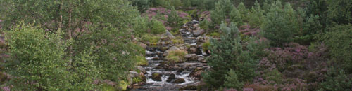
The gradient is steep throughout the upper catchment. Exposed bedrock, rapids, waterfalls and large boulders characterise the channel section utilised for biological monitoring and at low flow the stream bifurcates leaving large parts of the 10 m wide boulder-strewn bed exposed above the water line.
The Allt a'Mharcaidh catchment is extensively studied. As well as being a UK UWMN site it is subject to both terrestrial and freshwater monitoring by the Environmental Change Network, is a secondary site for the UK Eutrophying and Acidifying atmospheric Pollutants (UKEAP) network (UKEAP data available here) and is also in the UK National Ammonia Monitoring Network (ammonia monitoring data available here) and the UNECE International Cooperative Programme Integrated Monitoring Project. Data from the Allt a'Mharcaidh are contributed to the European Long-Term Ecosystem Research Network (LTER-Europe) and the International Long Term Ecological Research (ILTER) programmes.
[collapsed title="Water chemistry"]
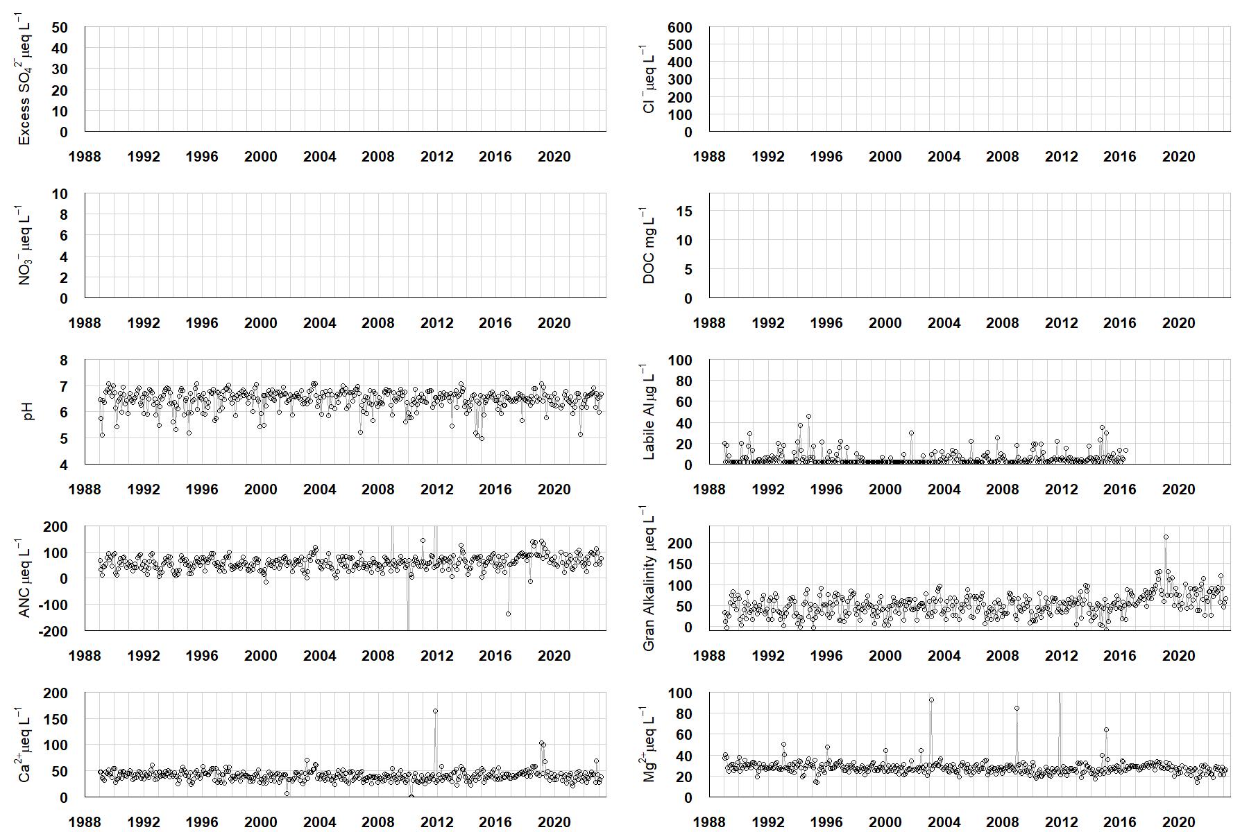
Excess SO42- = all sulphate not derived from marine salts; Cl- = chloride; NO3- = nitrate; DOC = dissolved organic carbon; Labile Al = inorganic monomeric (labile) aluminium; ANC = Acid Neutralising Capacity (determined by the difference (in equivalents) between total base cation concentration and total acid anion concentration); Gran Alkalinity = alkalinity determined by a Gran titration; Ca2+ = calcium; Mg2+ = magnesium.
[/collapse]
[collapsed title="Epilithic diatoms"]

Annual mean percentage abundance of the most common diatom taxa in replicate samples of the biofilm of stone surfaces. Taxa are arranged in the plot so that those that had their highest percentage abundances at the beginning of the monitoring record appear at the top of the figure, and those that have become most common at the end of the record appear at the bottom.
[/collapsed]
[collapsed title=Macroinvertebrates]
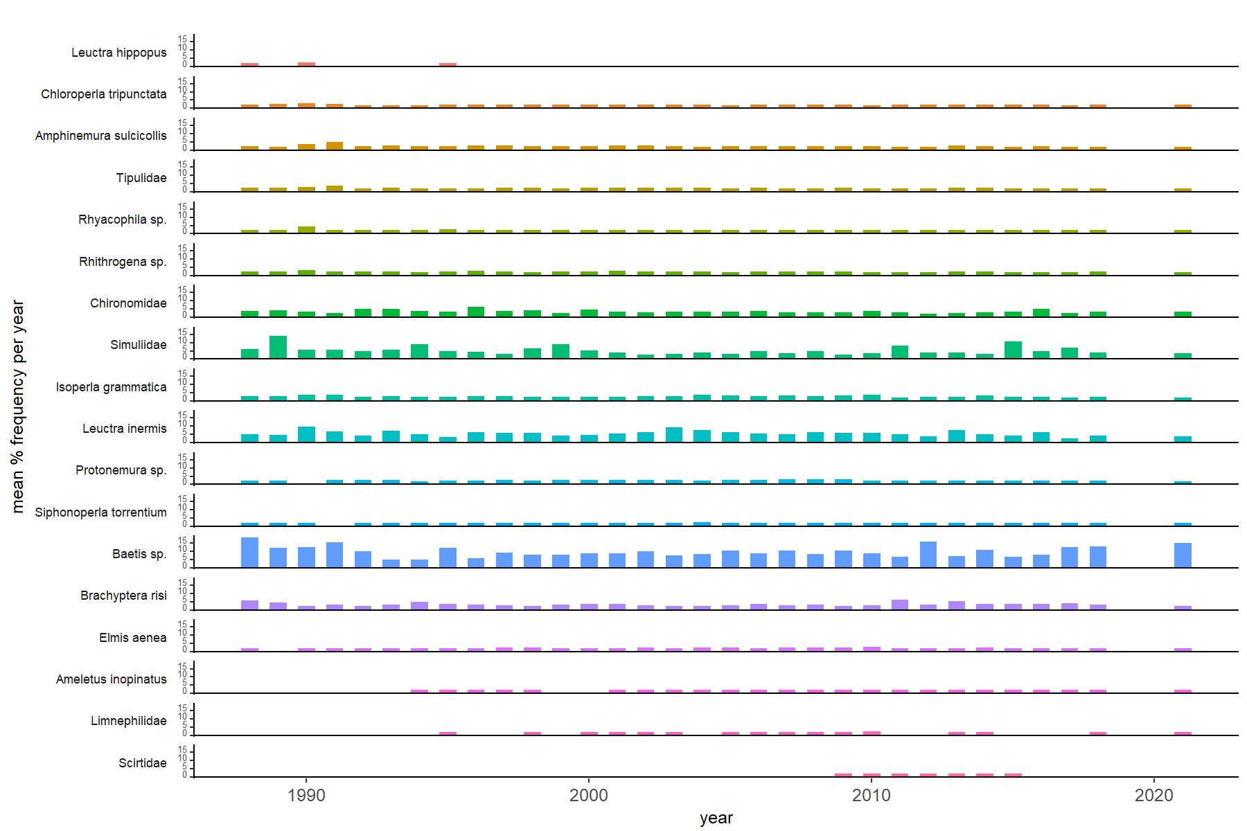
Abundance of the most common macroinvertebrate taxa as a percentage of all individuals collected in five bulked kick samples. Taxa are arranged in the plot so that those with their highest percentage abundances at the beginning of the monitoring record appear at the top of the figure, and those that have become most common at the end of the record appear at the bottom.
[/collapse]
[collapsed title=Allt a'Mharcaidh Bibliography]
[/collapse]