- Location: north-eastern Northern Ireland
- Type: Stream
- Catchment area: 302 ha
- Annual rainfall: c. 1600 mm
- Sampling station altitude: 230 m
- Maximum altitude: 397 m
Beagh's Burn lies in the Glens of Antrim in north-eastern Northern Ireland. The catchment area is 302 ha and rises steeply from 150 m, just above the confluence with the Glendun River, to a maximum of 397 m at Oghtbristacree. Localised mineral soils in the lowermost area give way to blanket peats which dominate most of the catchment. In the upper catchment the peat is partly drained and in places extensively eroded. The underlying geology is quartz-schists of the Glendun series.
Deciduous trees grow on the steep slopes immediately adjacent to the lowermost stream stretch which coincides with the sampling station. Elsewhere moorland species characterised by Calluna, Molinia and Sphagnum mosses, comprise the catchment vegetation. Old walls, derelict sheep pens and improvement of the lowest grazing land attest to a former level of land-use which exceeded the present low intensity sheep grazing.
The annual rainfall is c. 1600 mm.
The entire catchment lies within the Antrim Coast and Glens Area of Outstanding Natural Beauty and the majority is also part of the Antrim Hills Special Protection Area.
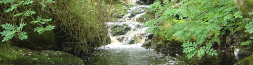
The altitude range is 230 m from the sampling station to the headwaters. The channel section utilised for biological sampling lies just upstream of the confluence with the Glendun River and is steep, being punctuated with waterfalls and rapids. The 2-4 m wide stream bed comprises mainly bedrock, boulders and cobbles and the sampling reach is heavily shaded by ash, willow and hawthorn in summer.
Beagh's Burn is also a site for the UK Eutrophying and Acidifying atmospheric Pollutants (UKEAP) network, data from which are available here.
[collapsed title="Water chemistry"]
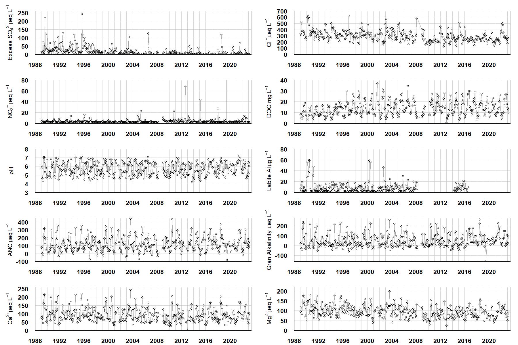
Excess SO42- = all sulphate not derived from marine salts; Cl- = chloride; NO3- = nitrate; DOC = dissolved organic carbon; Labile Al = inorganic monomeric (labile) aluminium; ANC = Acid Neutralising Capacity (determined by the difference (in equivalents) between total base cation concentration and total acid anion concentration); Gran Alkalinity = alkalinity determined by a Gran titration; Ca2+ = calcium; Mg2+ = magnesium.
[/collapse]
[collapsed title="Epilithic diatoms"]

Annual mean percentage abundance of the most common diatom taxa in replicate samples of the biofilm of stone surfaces. Taxa are arranged in the plot so that those that had their highest percentage abundances at the beginning of the monitoring record appear at the top of the figure, and those that have become most common at the end of the record appear at the bottom.
[/collapsed]
[collapsed title=Macroinvertebrates]
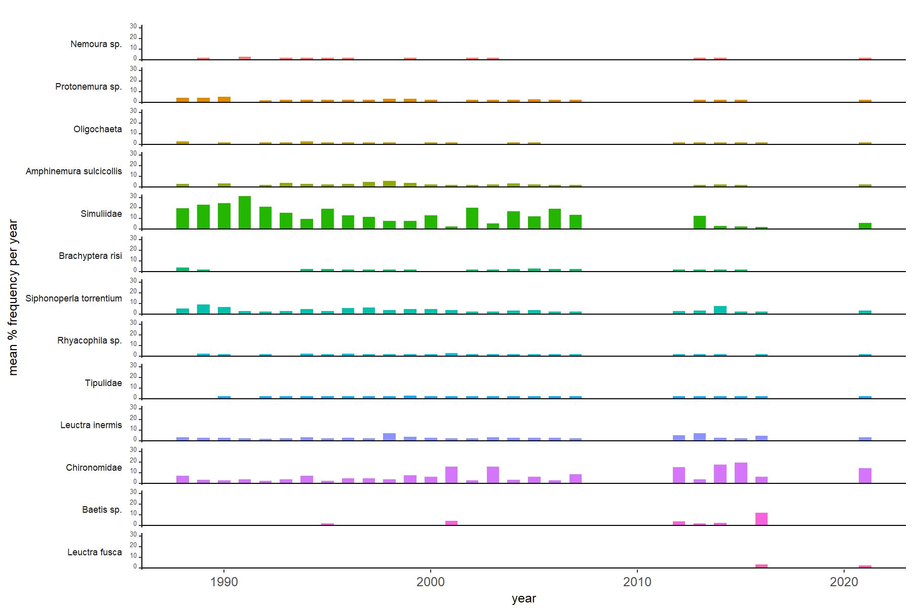
Abundance of the most common macroinvertebrate taxa as a percentage of all individuals collected in five bulked kick samples. Taxa are arranged in the plot so that those with their highest percentage abundances at the beginning of the monitoring record appear at the top of the figure, and those that have become most common at the end of the record appear at the bottom.
[/collapse]
[collapse title=Beagh's Burn Bibliography]
[/collapse]