- Location: Mourne Mountains of south-eastern Northern Ireland
- Type: Lake
- Catchment area: 48 ha
- Annual rainfall: c. 1600 mm
- Lake area: 1.9 ha
- Lake altitude: 340 m
Blue Lough is situated in a col between the Silent Valley and Annalong Valley in the Mourne Mountains of south-eastern Northern Ireland, very close to Bencrom River. The catchment is small (48 ha), but is steep and rugged, reaching a maximum altitude of 703 m. The solid geology of the catchment consists of granite which is exposed as bare rock and scree on the steep backwall and is covered with thin and often eroded blanket peat, peaty podsols and peaty gleys in the less steep areas. Bare rock, scree and eroded peat characterise the catchment, but elsewhere the vegetation is dominated by Calluna which in places is mature and in others has been intensively burnt. Land-use and management is restricted to low-intensity sheep grazing and occasional heather burning.
Annual rainfall is c. 1600 mm.
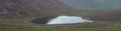
Blue Lough is a small (1.9 ha) circular lake lying at 340 m altitude. The lough has no discrete inflow and drains through a Sphagnum bog to a tributary of the Annalong River. The bathymetry reveals a shallow concentric basin offset to the east, with a maximum depth of 5 m.
The site lies within the Eastern Mournes Area of Special Scientific Interest and Special Area of Conservation, as well as the Mourne Area of Outstanding Natural Beauty.
UK UWMN data from the site contributes to the UNECE International Cooperative Programme on Assessment and Monitoring of Acidification of Rivers and Lakes.
[collapsed title="Water chemistry"]
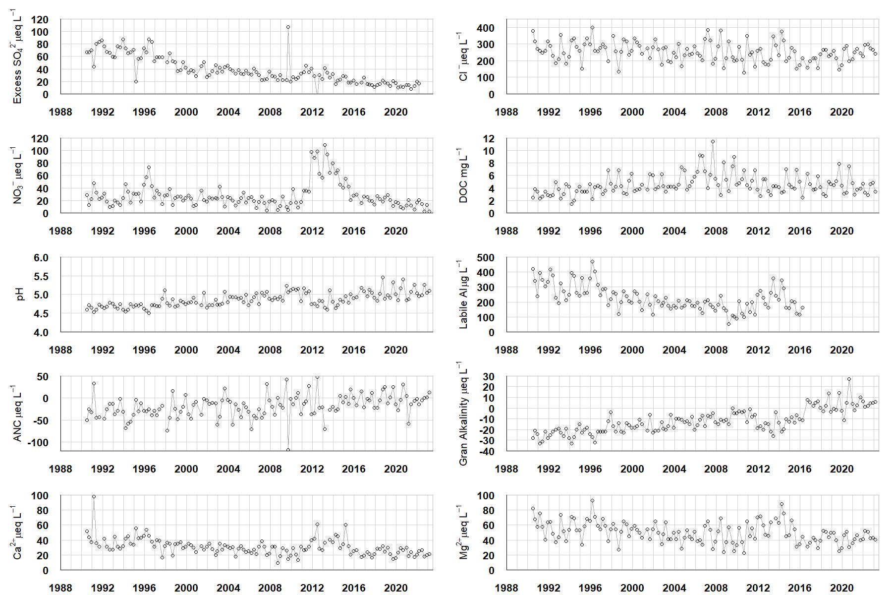
Excess SO42- = all sulphate not derived from marine salts; Cl- = chloride; NO3- = nitrate; DOC = dissolved organic carbon; Labile Al = inorganic monomeric (labile) aluminium; ANC = Acid Neutralising Capacity (determined by the difference (in equivalents) between total base cation concentration and total acid anion concentration); Gran Alkalinity = alkalinity determined by a Gran titration; Ca2+ = calcium; Mg2+ = magnesium.
[/collapse]
[collapsed title="Epilithic diatoms"]

Annual mean percentage abundance of the most common diatom taxa in replicate samples of the biofilm of stone surfaces. Taxa are arranged in the plot so that those that had their highest percentage abundances at the beginning of the monitoring record appear at the top of the figure, and those that have become most common at the end of the record appear at the bottom.
[/collapsed]
[collapsed title=Macroinvertebrates]
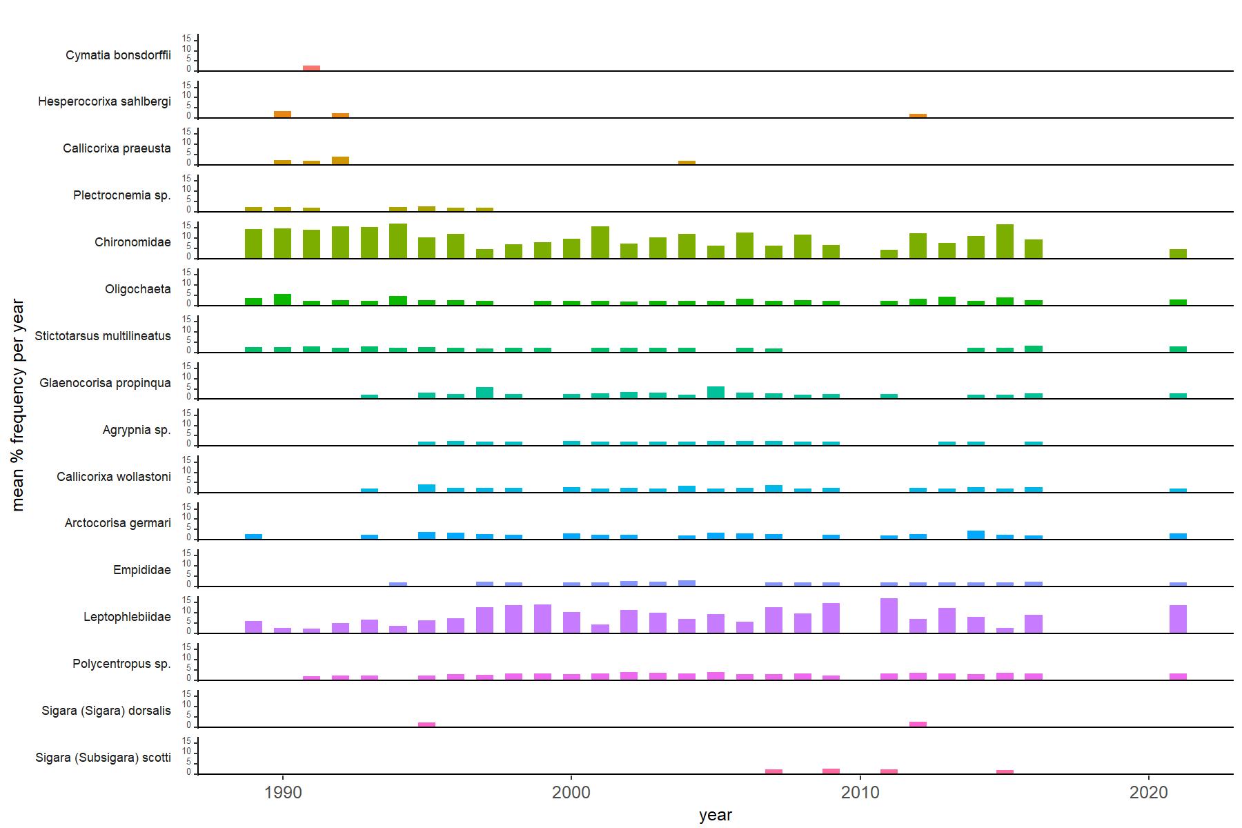
Abundance of the most common macroinvertebrate taxa as a percentage of all individuals collected in five bulked kick samples. Taxa are arranged in the plot so that those with their highest percentage abundances at the beginning of the monitoring record appear at the top of the figure, and those that have become most common at the end of the record appear at the bottom.
[/collapse]
[collapsed title=Blue Lough Bibliography]
[/collapse]