- Location: Snowdonia National Park, north Wales
- Type: Lake
- Catchment area: 152 ha
- Annual rainfall: c. 3000 mm
- Lake area: 5.1 ha
- Lake altitude: 375 m
Falling within the Snowdonia National Park, the Llyn Llagi catchment covers 152 ha and reaches a maximum altitude of 672 m. The geology consists primarily of Ordovician slates and shales of the Glanarfon series. The backwall is composed of a large doleritic intrusion with small intrusions of fine microgranites and volcanic tuff. Away from the precipitous bare rock of the backwall the catchment soils are chiefly stagnopodsols interspersed with blanket peats.
The lake and its catchment receive an annual rainfall of c. 3000 mm.
The catchment is unafforested and characterised by acid moorland species, notably Calluna, Festuca, Nardus, Molinia and Eriophorum. Palynological studies have shown that during the recent history of the catchment Calluna declined whilst Gramineae species increased. The vegetation has been grazed at a low intensity by sheep, and since 2008 cattle, but there is no other contemporary land-management.
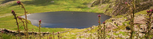
Llyn Llagi occupies a north-facing corrie in the central area of the Snowdonia region of north Wales. The lake lies at 375 m beneath a steep backwall and comprises a deep, almost circular, basin (maximum depth 16.5 m) bordered to the north by an extensive shallow (1 m deep) rim. The lake covers an area of 5.1 ha and receives discrete drainage from a series of small streams draining the steeper part of the catchment. The primary inflow constitutes the outflow stream from Llyn yr Adar which lies above the backwall. The lake drains to the north-west to the Afon Nanmor, a tributary of the Afon Glaslyn.
Llyn Llagi is part of the UNECE International Cooperative Programme on Assessment and Monitoring of Acidification of Rivers and Lakes and hosts a bulk deposition collector for the UK Eutrophying and Acidifying atmospheric Pollutants (UKEAP) network, data from which are available. UK UWMN data from Llyn Llagi are contributed to the UK Environmental Change Network, the European Long-Term Ecosystem Research Network (LTER Europe) and the International Long Term Ecological Research (ILTER) programme.
The lake has been designated as a site in the Environment Agency's Water Framework Directive Lake Surveillance Network. The UK UWMN contributes the biological and chemical data required for this statutory monitoring.
Click on a heading to expand/collapse each panel
[collapsed title=Water chemistry]
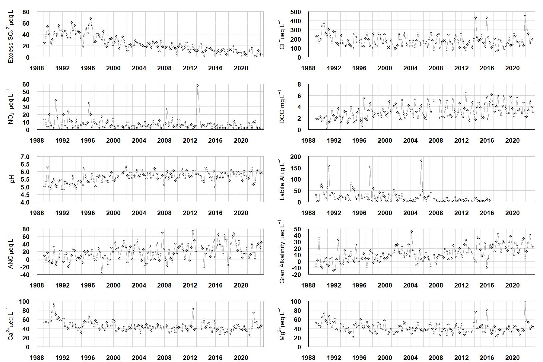
Excess SO42- = all sulphate not derived from marine salts; Cl- = chloride; NO3- = nitrate; DOC = dissolved organic carbon; Labile Al = inorganic monomeric (labile) aluminium; ANC = Acid Neutralising Capacity (determined by the difference (in equivalents) between total base cation concentration and total acid anion concentration); Gran Alkalinity = alkalinity determined by a Gran titration; Ca2+ = calcium; Mg2+ = magnesium.
[/collapse]
[collapsed title=Epilithic diatoms]

Annual mean percentage abundance of the most common diatom taxa in replicate samples of the biofilm of stone surfaces. Taxa are arranged in the plot so that those that had their highest percentage abundances at the beginning of the monitoring record appear at the top of the figure, and those that have become most common at the end of the record appear at the bottom.
[/collapse]
[collapsed title=Macroinvertebrates]
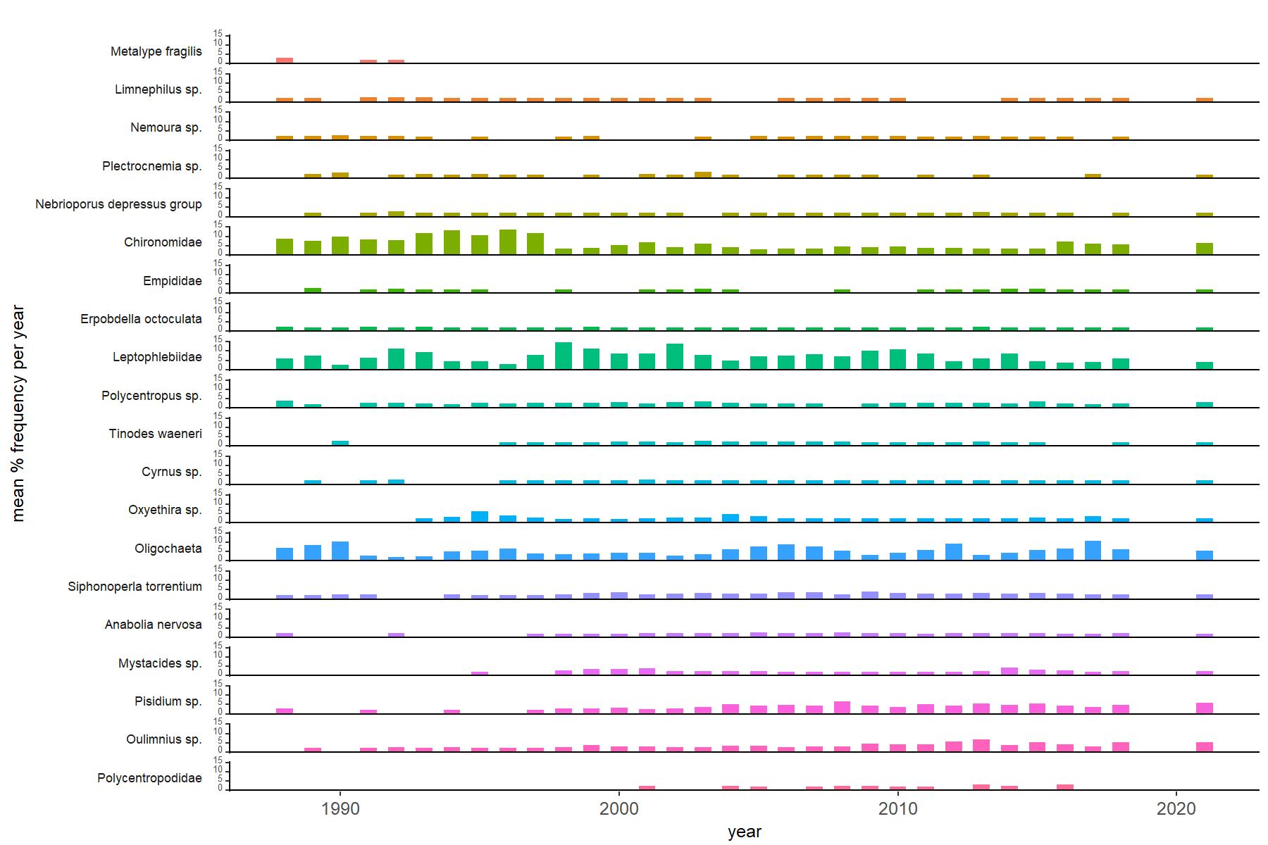
Abundance of the most common macroinvertebrate taxa as a percentage of all individuals collected in five bulked kick samples. Taxa are arranged in the plot so that those with their highest percentage abundances at the beginning of the monitoring record appear at the top of the figure, and those that have become most common at the end of the record appear at the bottom.
[/collapse]
[collapsed title=Llyn Llagi Bibliography]
[/collapse]