Loch Coire Fionnaraich
- Location: North-west Scotland
- Type: Lake
- Catchment area: 550 ha
- Annual rainfall: c. 3300 mm
- Lake area: 9.3 ha
- Lake altitude: 236 m

Loch Coire Fionnaraich
Loch Coire Fionnaraich has a catchment of 550 ha, with a range of elevation from 236 m at the outflow to 933 m at the summit of Maol Chean-dearg. Whilst a band of Cambrian basal quartzite and "Pipe Rock" crosses beneath the northern side of the loch, the catchment geology is mostly made up of Torridonian sandstones from the Applecross and Aultbea groups. Catchment soils consist of peats and peaty podsols alongside extensive areas of exposed rock. Vegetation is dominated by Molinia and Calluna and the catchment is treeless. The surrounding moorland is managed for red deer and low numbers of feral goats are also present. A popular hiking path passes along the western shore of the loch. There are a number of very small lochans and pools on the catchment's northern boundary and one more in the north-west.
The annual rainfall is c. 3300 mm.
Note: Loch Coire Fionnaraich was added to the Network in 2001 as a replacement site for the nearby and dammed Loch Coire nan Arr.
Loch Coire Fionnaraich lies at 236 m, set back somewhat from the headwall of a south-east facing coire. The loch covers an area of 9.3 hectares and is fed by five minor streams, including the Allt Ban Tigh Mhit an Toisich and one large one, the Allt Bealach Ban (after it's confluence with the Allt Creag na h-lolaire). Dammed by moraine, the loch drains five and a half kilometres, almost due south, into the River Carron via the Fionn-abhainn outflow stream. The bathymetry demonstrates twin basins, the larger and deeper of which reaches a depth of 14m.
The loch has replaced Loch Coire nan Arr as one of the six UK sites represented in the UNECE International Co-operative Programme on Assessment and Monitoring of Acidification of Rivers and Lakes (UNECE - ICP Waters).
[collapsed title="Water chemistry"]

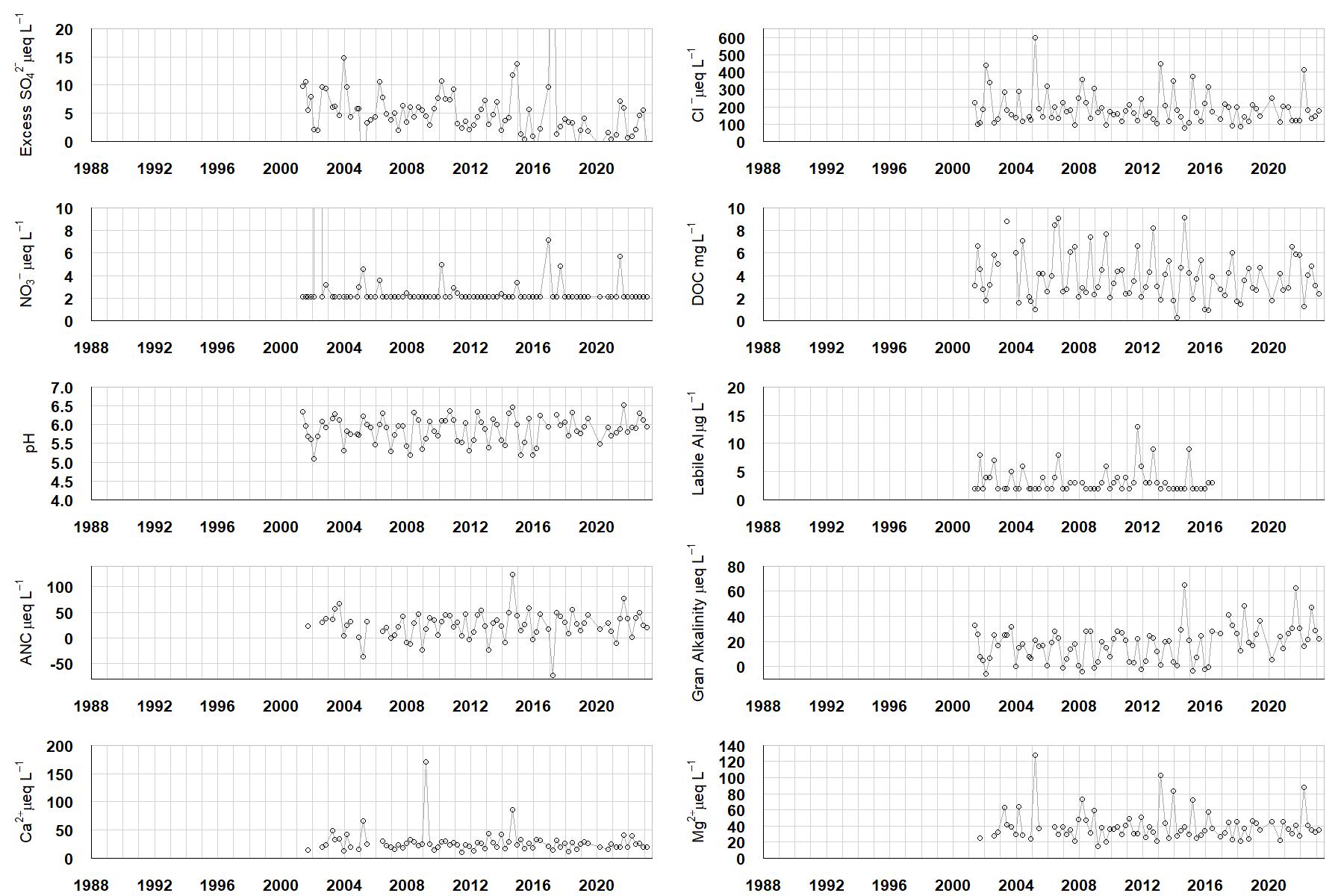
Excess SO42- = all sulphate not derived from marine salts; Cl- = chloride; NO3- = nitrate; DOC = dissolved organic carbon; Labile Al = inorganic monomeric (labile) aluminium; ANC = Acid Neutralising Capacity (determined by the difference (in equivalents) between total base cation concentration and total acid anion concentration); Gran Alkalinity = alkalinity determined by a Gran titration; Ca2+ = calcium; Mg2+ = magnesium.
[/collapse]
[collapsed title="Epilithic diatoms"]

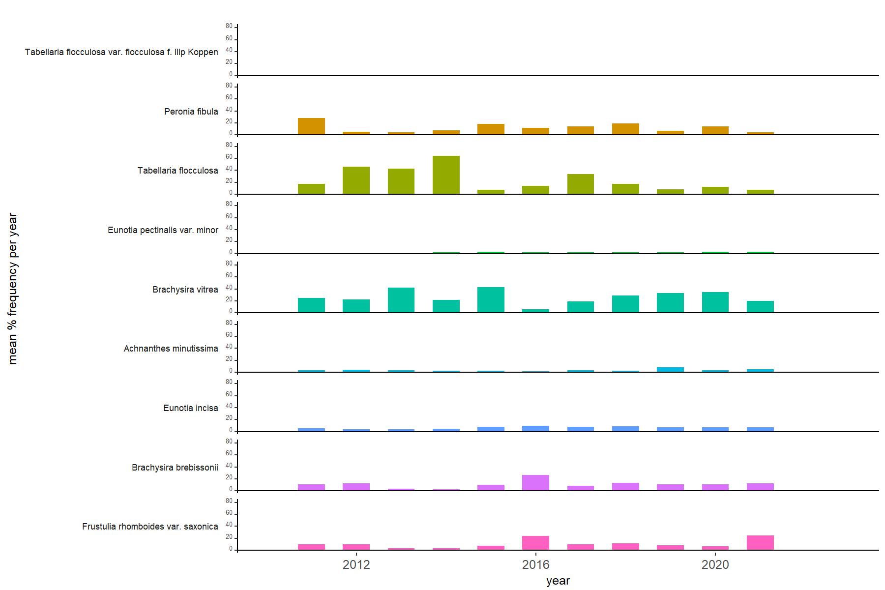
Annual mean percentage abundance of the most common diatom taxa in replicate samples of the biofilm of stone surfaces. Taxa are arranged in the plot so that those that had their highest percentage abundances at the beginning of the monitoring record appear at the top of the figure, and those that have become most common at the end of the record appear at the bottom.
[/collapsed]
[collapsed title=Macroinvertebrates]

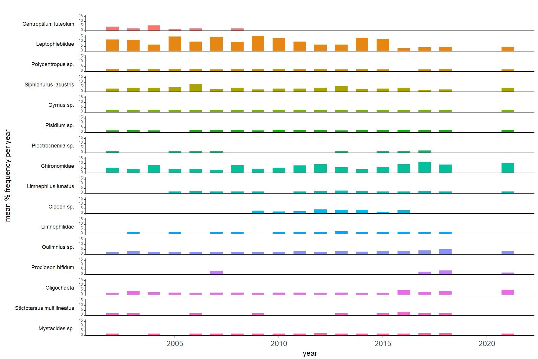
Abundance of the most common macroinvertebrate taxa as a percentage of all individuals collected in five bulked kick samples. Taxa are arranged in the plot so that those with their highest percentage abundances at the beginning of the monitoring record appear at the top of the figure, and those that have become most common at the end of the record appear at the bottom.
[/collapse]
[collapsed title="Loch Coire Fionnaraich Bibliography"]
[/collapse]