- Location: Trossachs, central Scotland
- Type: Lake
- Catchment area: 121 ha
- Annual rainfall: c. 2300 mm
- Lake area: 11.1 ha
- Lake altitude: 418 m
Situated next to Loch Chon in the Trossachs, Loch Tinker drains a catchment of 121 ha which reaches a maximum altitude of 700 m at Beinn Chochan in the south-east. The geology is similar to that in the adjacent Loch Chon catchment and comprises metamorphosed sediments of the Oalradian group and belts of less resistant 'green beds'. Peaty gleys dominate the catchment soils.
Annual rainfall is c. 2300 mm.
The catchment is unafforested and its blanket peats are characterised by the moorland species Calluna and Molinia. At the onset of monitoring the catchment was grazed by sheep and until the 1930s was managed for grouse by regular heather burning, but is no longer burnt. An interesting vegetational contrast is apparent on the small ungrazed islands in the loch where shrubby species and small birch trees persist. No discernable vegetational or land use changes have occurred within the catchment during the monitoring period. Both the loch and its catchment lie within the Loch Lomond and Trossachs National Park.
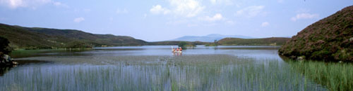
Named Lochan a' Cheaird on historic maps, Loch Tinker lies at 418 m altitude and drains an adjacent catchment to the east of Loch Chon in the Trossachs region of central Scotland. The loch receives drainage from seepage through the catchment blanket peats and from the steep slopes to the south and east, although the main stream in this area is naturally captured just a few metres downstream of the loch outflow. The loch drains to the north east via the Allt Glasahoile which falls steeply to Loch Katrine. The loch (surface area 11.1 ha) has an irregular shoreline and the generally shallow (mean depth 3.5 m) bathymetry includes two distinct sub-basins reaching a maximum depth of 9.8 m. Three small islands are located towards the southern end of the loch.
Bi-weekly bulk rainwater samples are collected from close to the site for the UK Eutrophying and Acidifying atmospheric Pollutants (UKEAP) network
[collapsed title="Water chemistry"]
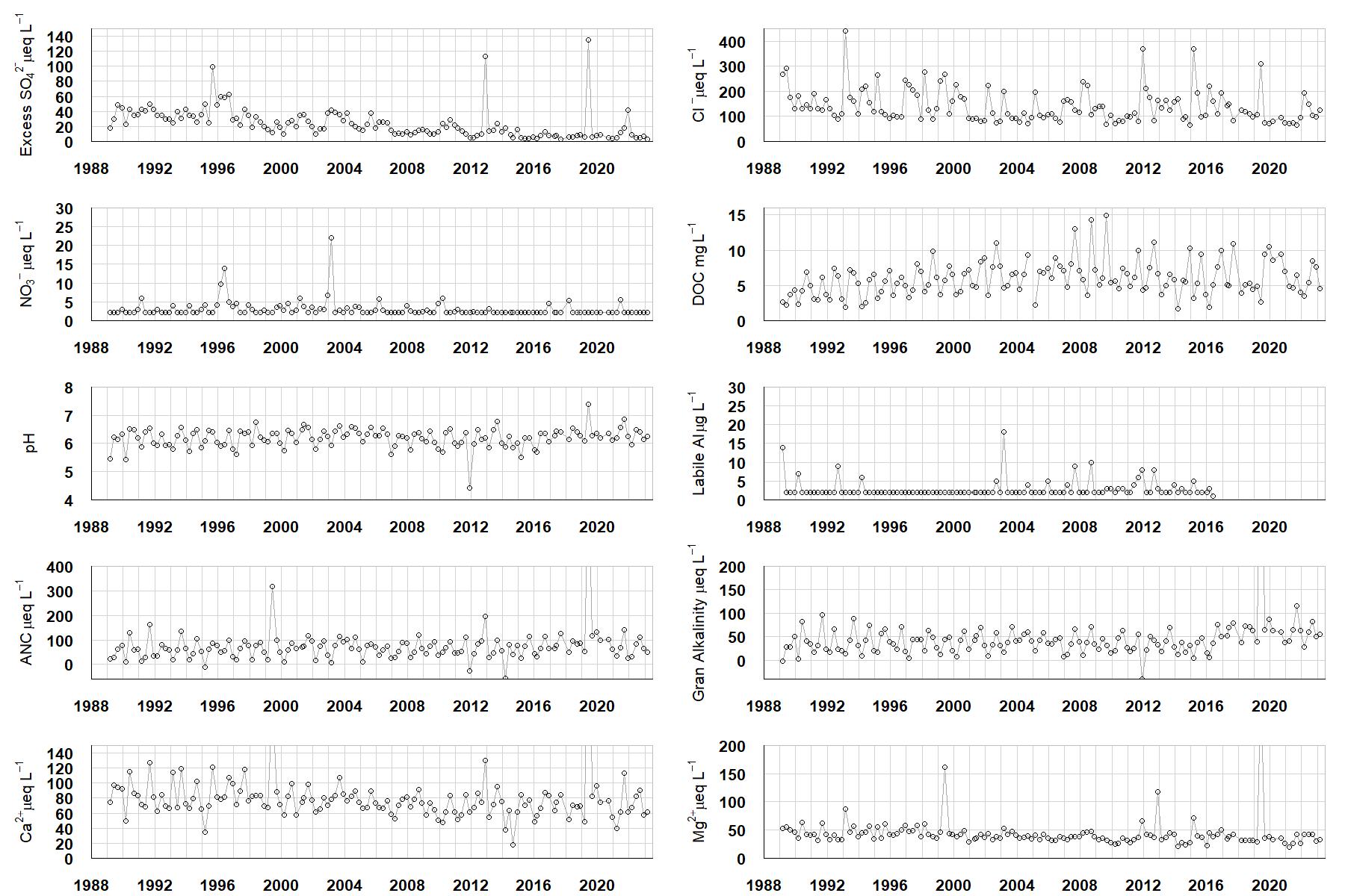
Excess SO42- = all sulphate not derived from marine salts; Cl- = chloride; NO3- = nitrate; DOC = dissolved organic carbon; Labile Al = inorganic monomeric (labile) aluminium; ANC = Acid Neutralising Capacity (determined by the difference (in equivalents) between total base cation concentration and total acid anion concentration); Gran Alkalinity = alkalinity determined by a Gran titration; Ca2+ = calcium; Mg2+ = magnesium.
[/collapse]
[collapsed title="Epilithic diatoms"]

Annual mean percentage abundance of the most common diatom taxa in replicate samples of the biofilm of stone surfaces. Taxa are arranged in the plot so that those that had their highest percentage abundances at the beginning of the monitoring record appear at the top of the figure, and those that have become most common at the end of the record appear at the bottom.
[/collapsed]
[collapsed title=Macroinvertebrates]
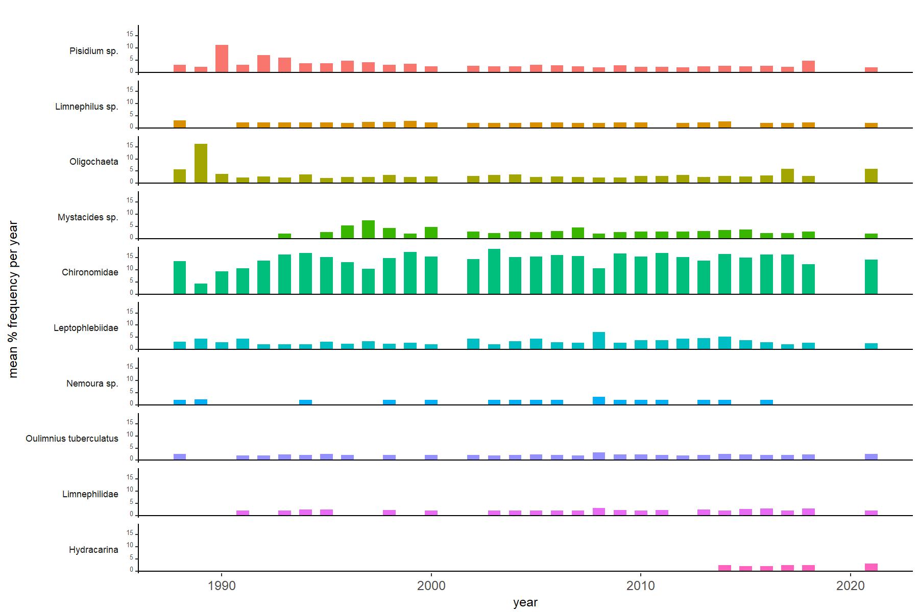
Abundance of the most common macroinvertebrate taxa as a percentage of all individuals collected in five bulked kick samples. Taxa are arranged in the plot so that those with their highest percentage abundances at the beginning of the monitoring record appear at the top of the figure, and those that have become most common at the end of the record appear at the bottom.
[/collapse]