- Location: Strontian region of western Scotland
- Type: Stream
- Catchment area: 817 ha
- Annual rainfall: c. 2580 mm
- Sampling location altitude: 10 m
- Maximum altitude: 756 m
The Allt na Coire nan Con catchment lies in the Strontian region of western Scotland and drains into the River Polloch, an inflow to Loch Shiel. The catchment covers 817 ha and rises from 10 m at the sampling point to a peak of 756 m in the east. The dominant soil types are subalpine soils, peaty podsols and peat gleys. Peat erosion occurs on the exposed uppermost reaches of the catchment. The underlying geology is primarily schists and gneisses, principally of the Moine series.
Approximately 40% of the catchment is covered by mature and maturing coniferous forest (mainly spruce and larch) through which a number of access tracks have been placed. Some felling and replanting has taken place during the monitoring period in areas of the lower catchment, especially to the south of the stream. The non-afforested upper slopes are dominated by Molinia interspersed with Calluna and in wetter areas, Sphagnum. Deer graze at low intensity in these areas.
Mean annual rainfall is c. 2580 mm.
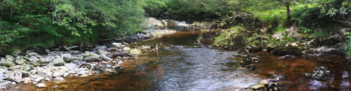
The altitude range is from 10m at the sampling station to 700 m at the headwaters. Exposed bedrock, boulders and a series of rapids and small waterfalls and deep pools characterise the 5-6 m wide channel section utilised for biological sampling. The stream reach in this area is partially shaded by bankside trees comprising mainly alder and rowan.
Bi-weekly bulk rainwater samples are collected from close to the site, at Polloch, for the UK Eutrophying and Acidifying atmospheric Pollutants (UKEAP) network, data from which are available here.
The Scottish Environmental Protection Agency (SEPA) operate an automatic river level monitoring station, also at Polloch, details of which can be found here.
[collapsed title="Water chemistry"]
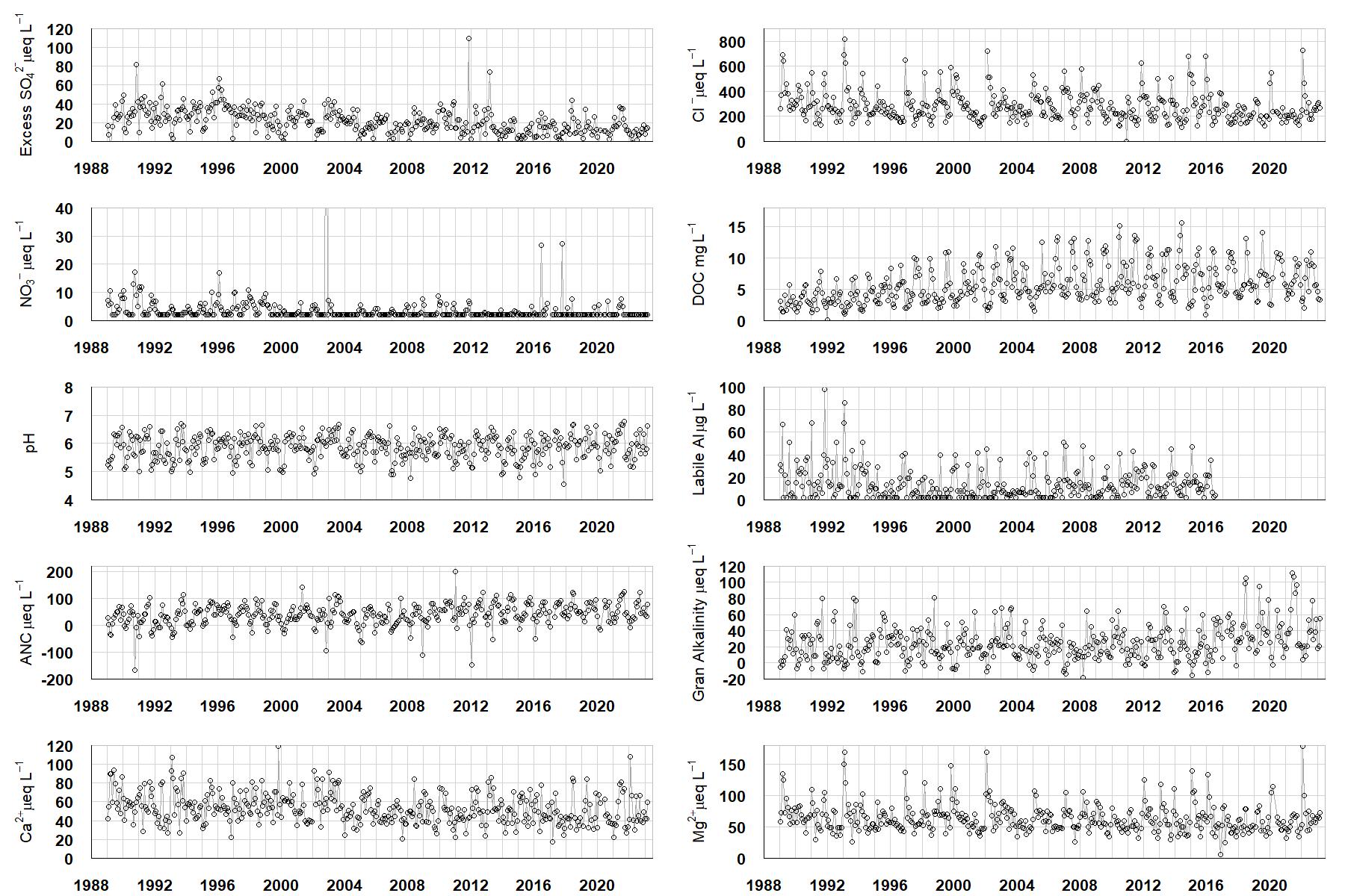
Excess SO42- = all sulphate not derived from marine salts; Cl- = chloride; NO3- = nitrate; DOC = dissolved organic carbon; Labile Al = inorganic monomeric (labile) aluminium; ANC = Acid Neutralising Capacity (determined by the difference (in equivalents) between total base cation concentration and total acid anion concentration); Gran Alkalinity = alkalinity determined by a Gran titration; Ca2+ = calcium; Mg2+ = magnesium.
[/collapse]
[collapsed title="Epilithic diatoms"]

Annual mean percentage abundance of the most common diatom taxa in replicate samples of the biofilm of stone surfaces. Taxa are arranged in the plot so that those that had their highest percentage abundances at the beginning of the monitoring record appear at the top of the figure, and those that have become most common at the end of the record appear at the bottom.
[/collapsed]
[collapsed title=Macroinvertebrates]
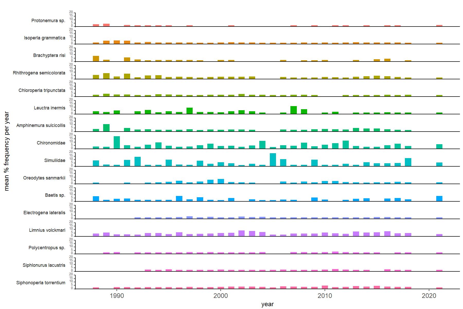
Abundance of the most common macroinvertebrate taxa as a percentage of all individuals collected in five bulked kick samples. Taxa are arranged in the plot so that those with their highest percentage abundances at the beginning of the monitoring record appear at the top of the figure, and those that have become most common at the end of the record appear at the bottom.
[/collapse]
[collapsed title=Allt na Coire nan Con Bibliography]
[/collapse]