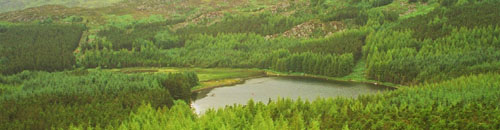
- Location: Rhinog Mountains, north Wales
- Type: Lake
- Catchment area: 119 ha
- Annual rainfall: c. 2200 mm
- Lake area: -
- Lake altitude: 287 m
Situated at the southern edge of the Rhinog Mountains in north Wales, the catchment of Llyn Cwm Mynach covers an area of 119 ha and reaches a maximum altitude of 680 m. The solid geology of the catchment consists of Cambrian siltstones to the north and grits and greywackes of the Cambrian Rhinog formation to the south. The north and east of the catchment is dominated by amorphous blanket peats, whereas acid ranker soils characterise the south and west. There are areas of exposed rock on the steeper slopes to the west.
The lake and its catchment receive an annual rainfall of c. 2200 mm.
Approximately half of the catchment is forested with Japanese larch, Lodgepole pine and Sitka spruce planted between 1967 and 1973. The remainder is acid moorland characterised by Calluna and Vaccinium and utilised as rough grazing for sheep. The remains of short-lived small manganese mines are to be found the south-west of the catchment but there is no evidence to suggest these abandoned excavations have had any effect on water chemistry during monitoring. Both the lake and the catchment lie within the Snowdonia National Park.
Llyn Cwm Mynach lies at 287 m altitude. The lake consists of two distinct basins; the southern section comprises a shallow limb separated from the deeper northern section by an old and broken stone causeway. The maximum depth of 11 m occurs in the northern basin in a localised hollow. Discrete drainage to the lake is by three small inflows and it is drained to the south-east by a small stream which flows to the Mawddach estuary. At some stage in the past a wooden weir (now derelict) was constructed at the outflow, presumably to raise the level of the southern section of the lake.
The llyn has been designated as a site in the Environment Agency's Water Framework Directive Lake Surveillance Network. The UK UWMN contributes the biological and chemical data required for this statutory monitoring.
[collapsed title="Water chemistry"]
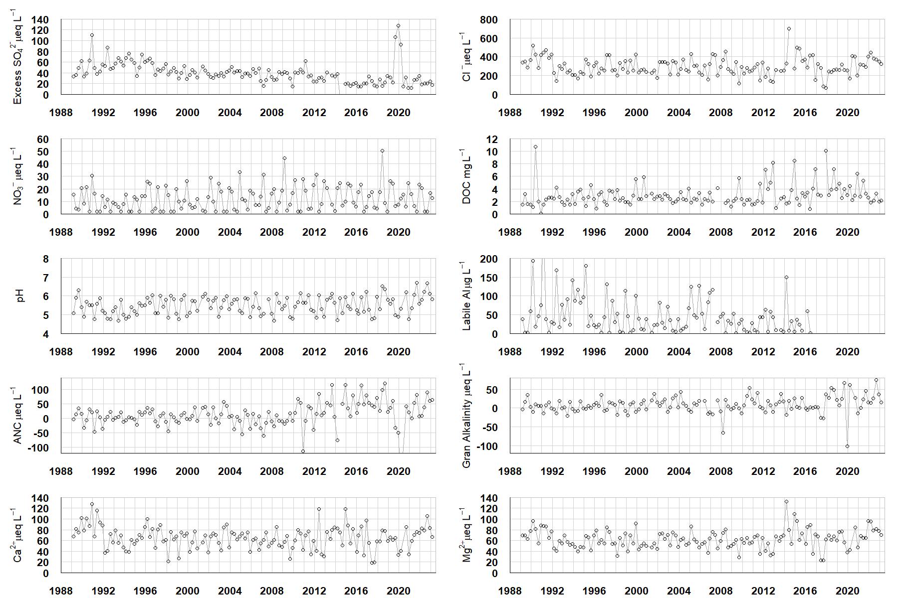
Excess SO42- = all sulphate not derived from marine salts; Cl- = chloride; NO3- = nitrate; DOC = dissolved organic carbon; Labile Al = inorganic monomeric (labile) aluminium; ANC = Acid Neutralising Capacity (determined by the difference (in equivalents) between total base cation concentration and total acid anion concentration); Gran Alkalinity = alkalinity determined by a Gran titration; Ca2+ = calcium; Mg2+ = magnesium.
[/collapse]
[collapsed title="Epilithic diatoms"]

Annual mean percentage abundance of the most common diatom taxa in replicate samples of the biofilm of stone surfaces. Taxa are arranged in the plot so that those that had their highest percentage abundances at the beginning of the monitoring record appear at the top of the figure, and those that have become most common at the end of the record appear at the bottom.
[/collapsed]
[collapsed title=Macroinvertebrates]
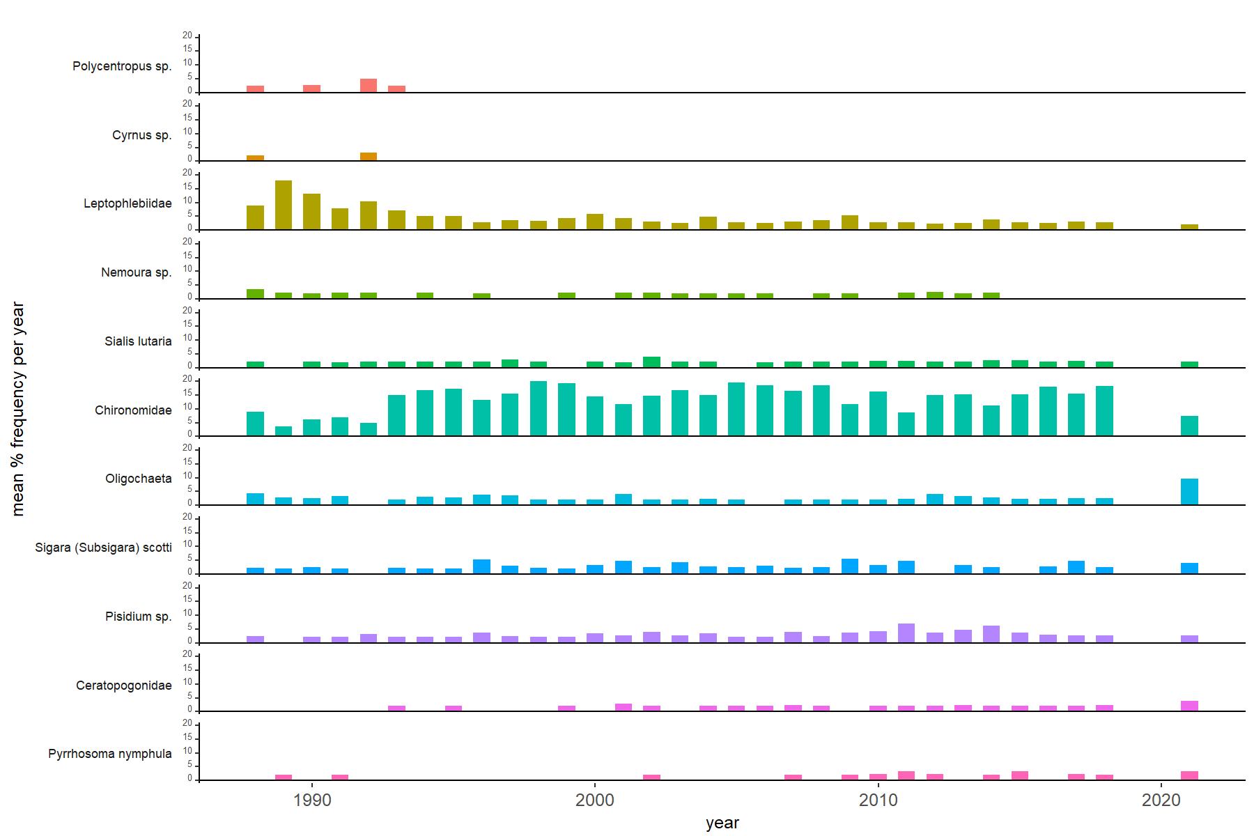
Abundance of the most common macroinvertebrate taxa as a percentage of all individuals collected in five bulked kick samples. Taxa are arranged in the plot so that those with their highest percentage abundances at the beginning of the monitoring record appear at the top of the figure, and those that have become most common at the end of the record appear at the bottom.
[/collapse]
[collapsed title=Llyn Cwm Mynach Bibliography]
[/collapse]