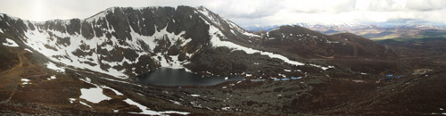
- Location: Cairngorms, Scotland
- Type: Lake
- Catchment area: 99 ha
- Annual rainfall: c. 1500 mm
- Lake area: 9.9 ha
- Lake altitude: 788 m
Lochnagar drains a precipitous Cairngorm catchment of 99 ha which reaches a maximum altitude of 1155 m at the summit of Lochnagar to the west of the loch. The geology is composed of biotite granite. The catchment is dominated by bare rock, both on the steep backwall and the extensive fields of large boulders and coarse screes that have developed between the corrie ridge and the loch.
The loch and its catchment receive an annual rainfall of c. 1500 mm.
The catchment is unafforested and the sparse vegetation is dominated by a community of stunted Calluna and Vaccinium, interspersed in places with Scirpus. Lichens and mosses are abundant on the boulders and screes that characterise the catchment. Of the localised areas of peat in the catchment, certain areas, notably along the eastern shore, are severely eroded. Pine stumps are revealed in peat exposures adjacent to the outflow and further down the Lochnagar Burn.
This area represents some of the harshest environmental conditions to be found in the British Isles. At over 700 m the catchment lies above the limit of summer sheep grazing in the region and there is no evidence for any land-use change or active land-management within the catchment. Red deer range freely across the catchment when food is available. There is a designated Special Protection Area extending south beyond the corrie headwall and the entire catchment falls within the Cairngorm National Park.
The loch lies at an altitude of 788 m in the centre of the granitic massif which comprises much of Balmoral Forest in Aberdeenshire. Lochnagar is a corrie loch and lies below a north-east facing steep backwall which rises to the summit of the same name. The loch is pear-shaped and occupies an area of 9.9 ha. No large inflows feed the loch and drainage is primarily from small seepage channels. The loch drains to the north east through a series of small pools to the Lochnagar Burn which feeds the Gelder Burn, a south bank tributary of the River Dee. Snow generally occupies the catchment to a varying extent between November and May and a significant snow field accumulates in the main winter period. Snow-melt therefore comprises a major input to the loch. Unlike other sites in the Network, Lochnagar regularly freezes each winter.
The bathymetry of the loch floor slopes quite sharply to a deep basin. The deepest point, at 24 m, is offset from the centre of the loch towards the backwall. The loch is deep for its area with a mean depth of 8.4 m.
Through the UK UWMN, the site is part of the UNECE International Cooperative Programme on Assessment and Monitoring of Acidification of Rivers and Lakes. Bi-weekly bulk rainwater samples are collected from the site for the UK Eutrophying and Acidifying atmospheric Pollutants (UKEAP) network, data from which are available here. UK UWMN data from Lochnagar are contributed to the UK Environmental Change Network, the European Long-Term Ecosystem Research Network (LTER-Europe) and the International Long Term Ecological Research (ILTER) programme.
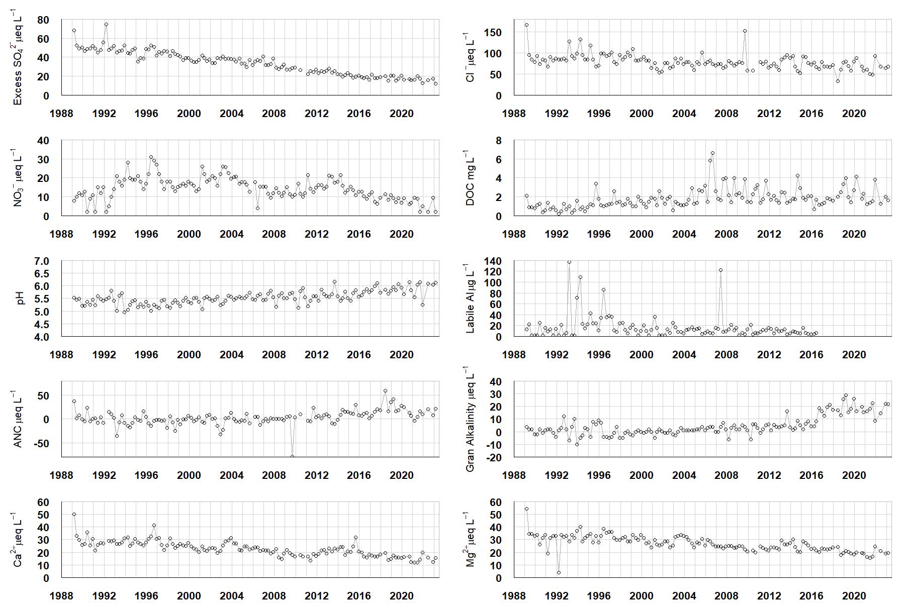
Excess SO42- = all sulphate not derived from marine salts; Cl- = chloride; NO3- = nitrate; DOC = dissolved organic carbon; Labile Al = inorganic monomeric (labile) aluminium; ANC = Acid Neutralising Capacity (determined by the difference (in equivalents) between total base cation concentration and total acid anion concentration); Gran Alkalinity = alkalinity determined by a Gran titration; Ca2+ = calcium; Mg2+ = magnesium.

Annual mean percentage abundance of the most common diatom taxa in replicate samples of the biofilm of stone surfaces. Taxa are arranged in the plot so that those that had their highest percentage abundances at the beginning of the monitoring record appear at the top of the figure, and those that have become most common at the end of the record appear at the bottom.
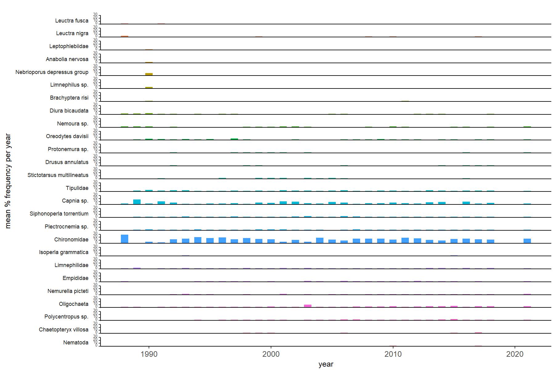
Abundance of the most common macroinvertebrate taxa as a percentage of all individuals collected in five bulked kick samples. Taxa are arranged in the plot so that those with their highest percentage abundances at the beginning of the monitoring record appear at the top of the figure, and those that have become most common at the end of the record appear at the bottom.