- Location: Galloway, south west Scotland
- Type: Lake
- Catchment area: 90 ha
- Annual rainfall: c. 2300 mm
- Lake area: 12.7 ha
- Lake altitude: 298 m
Loch Grannoch, in the Galloway region of south-west Scotland, drains a catchment of 1321 ha which has a maximum altitude of 601 m. Geologically it forms part of the Cairnsmore of Fleet granite intrusion. The catchment soils comprise blanket peat, peaty podsols and peaty gleys with rankers and bare rock at higher altitudes.
The site receives c. 2300 mm of rainfall.
The catchment is largely (~60%) afforested with Douglas fir and Sitka spruce. Planting occurred in two phases: in 1962 and 1977- 1978. To date two large Coupes have been felled, one in 2001 on the northern edge of the catchment and the other in 1999 between the eastern shore of the loch and the main access track. The unafforested sector is characterised by acid Molinia heath species with locally abundant Calluna and Myrica. Most of the moorland area to the south west of the catchment falls within the Cairnsmore of Fleet SSSI, NNR and UNESCO biosphere reserve. The entire catchment lies within the Galloway Forest Park. Low density sheep grazing is still maintained on the unafforested areas but the proximity of forest means that burning is no longer practiced as a land-management technique. A fishing and game lodge on the southern shore is now rarely used and is not considered to make a significant impact on the loch or its catchment.
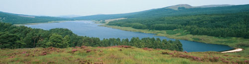
Loch Grannoch is a large (surface area 111.4 ha), elongated lake which lies at 214 m altitude. Small streams feed the loch along its eastern and western shores, the principal of which is the Cuttimore Burn. It drains to the north into the River Dee via the Pullaugh Burn. The loch bathymetry was first surveyed by Murray and Pullar in 1910 and was updated by a subsequent survey by the Palaeoecology Research Unit of University College London. The major basin is offset to the south of the loch and reaches a maximum depth of 20.5 m.
The Loch has been selected to form part of the the Scottish Environmental Protection Agency's Water Framework Directive lake surveillance network and UK UWMN data will contribute towards the next round of assessments.
[collapsed title="Water chemistry"]
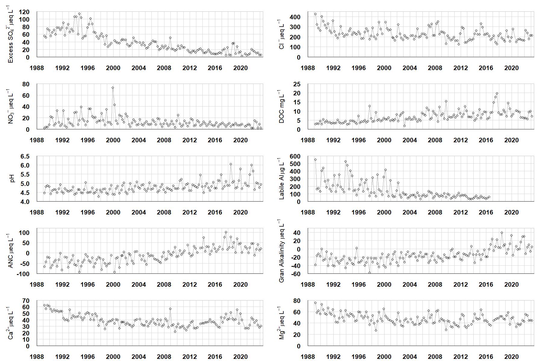
Excess SO42- = all sulphate not derived from marine salts; Cl- = chloride; NO3- = nitrate; DOC = dissolved organic carbon; Labile Al = inorganic monomeric (labile) aluminium; ANC = Acid Neutralising Capacity (determined by the difference (in equivalents) between total base cation concentration and total acid anion concentration); Gran Alkalinity = alkalinity determined by a Gran titration; Ca2+ = calcium; Mg2+ = magnesium.
[/collapse]
[collapsed title="Epilithic diatoms"]

Annual mean percentage abundance of the most common diatom taxa in replicate samples of the biofilm of stone surfaces. Taxa are arranged in the plot so that those that had their highest percentage abundances at the beginning of the monitoring record appear at the top of the figure, and those that have become most common at the end of the record appear at the bottom.
[/collapsed]
[collapsed title=Macroinvertebrates]
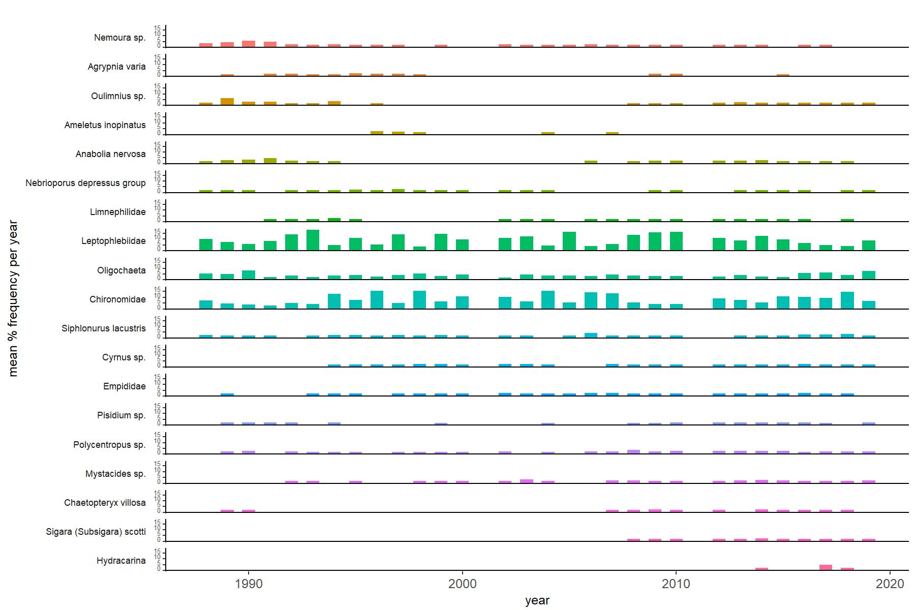
Abundance of the most common macroinvertebrate taxa as a percentage of all individuals collected in five bulked kick samples. Taxa are arranged in the plot so that those with their highest percentage abundances at the beginning of the monitoring record appear at the top of the figure, and those that have become most common at the end of the record appear at the bottom.
[/collapse]
[collapsed title="Loch Grannoch Bibliography"]
[/collapse]