- Location: Galloway, south west Scotland
- Type: Lake
- Catchment area: 90 ha
- Annual rainfall: c. 2300 mm
- Lake area: 12.7 ha
- Lake altitude: 298 m
The Round Loch of Glenhead, in Galloway Scotland, drains a catchment of 90 ha, which to the north and north-east rises to the steep cliffs of Craiglee and an altitude of 531 m. The catchment lies on the Loch Doon granite intrusion and the rocks include tonalite and those of a tonalite/granite transition. The catchment soils are dominated by deep peat and peaty podsols, with skeletal soils and bare rock characterising the steepest slopes.
The loch and its catchment lie in an area of high rainfall (c. 2300 mm).
The catchment is unafforested and the moorland vegetation is dominated by Molinia, Erica, Pteridium and Trichophorum and includes other species commonly associated with upland blanket mires such as Calluna, Nardus and Potentilla. This community was maintained by low-density sheep grazing and periodic burning until the late 1990s when Forest Enterprise in conjunction with Scottish Natural Heritage replaced the sheep with low numbers of cattle. Both the loch and catchment fall within the Merrick Kells Site of Special Scientific Interest (SSSI) and Special Area of Conservation (SAC), and the Silver Flowe-Merrick Kells UNESCO biosphere reserve.
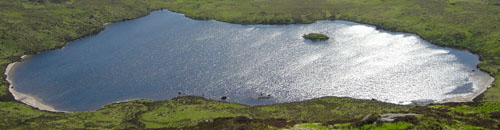
The site lies at 298 m altitude in the Galloway region of south-west Scotland. The loch is 12.7 ha in area and receives drainage from minor streams and catchment blanket peats. The outflow drains to the south-west into the Glenhead Burn and Loch Trool. The loch bathymetry indicates a single deep basin (maximum depth 13.5 m) offset to the south with slopes rising gently away from the southern shore. An island is located just off the western shore some 250 m from the outflow.
The loch, through the UK UWMN, is part of the UNECE International Cooperative Programme on Assessment and Monitoring of Acidification of Rivers and Lakes.
An automatic lake monitoring hydro-met station has been sited on the loch since 2005. As of 2011 this became part of the UK Lake Ecological Observatory Network.
[collapsed title="Water chemistry"]
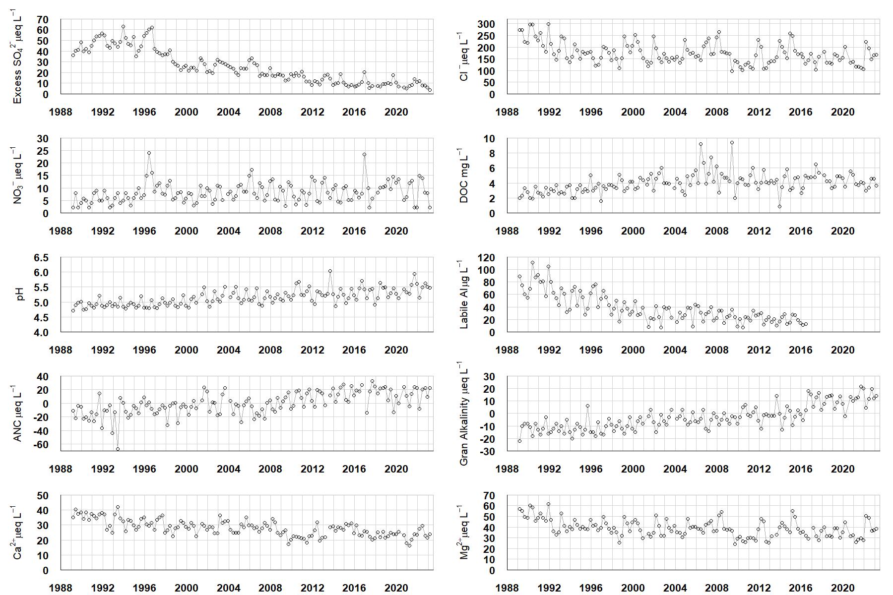
Excess SO42- = all sulphate not derived from marine salts; Cl- = chloride; NO3- = nitrate; DOC = dissolved organic carbon; Labile Al = inorganic monomeric (labile) aluminium; ANC = Acid Neutralising Capacity (determined by the difference (in equivalents) between total base cation concentration and total acid anion concentration); Gran Alkalinity = alkalinity determined by a Gran titration; Ca2+ = calcium; Mg2+ = magnesium.
[/collapse]
[collapsed title="Epilithic diatoms"]

Annual mean percentage abundance of the most common diatom taxa in replicate samples of the biofilm of stone surfaces. Taxa are arranged in the plot so that those that had their highest percentage abundances at the beginning of the monitoring record appear at the top of the figure, and those that have become most common at the end of the record appear at the bottom.
[/collapsed]
[collapsed title=Macroinvertebrates]
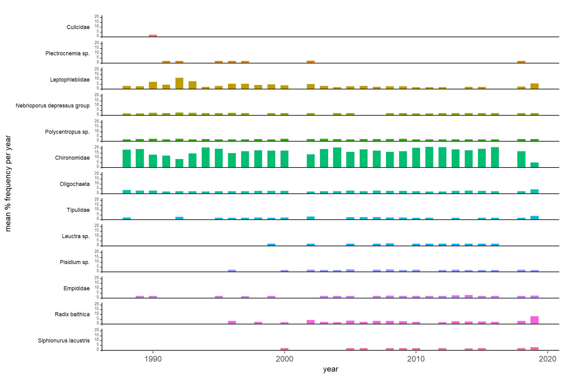
Abundance of the most common macroinvertebrate taxa as a percentage of all individuals collected in five bulked kick samples. Taxa are arranged in the plot so that those with their highest percentage abundances at the beginning of the monitoring record appear at the top of the figure, and those that have become most common at the end of the record appear at the bottom.
[/collapse]
[collapsed title="Round Loch of Glenhead Bibliography"]
[/collapse]